
Topografische Karte Rabka-Zdrój
Interaktive Karte
Klicken Sie auf die Karte, um die Höhe anzuzeigen.
Über diese Karte
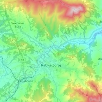
Name: Topografische Karte Rabka-Zdrój, Höhe, Relief.
Durchschnittliche Höhe: 594 m
Minimale Höhe: 422 m
Maximale Höhe: 1.007 m
Andere topografische Karten
Klicken Sie auf eine Karte, um ihre Topografie, ihre Höhe und ihr Relief anzuzeigen.
Ciptowski
Poland > Lesser Poland Voivodeship > Nowy Targ County > Łapszanka
Ciptowski, Łapszanka, gmina Łapsze Niżne, Nowy Targ County, Lesser Poland Voivodeship, 34-442, Poland
Durchschnittliche Höhe: 898 m
Obidowa
Poland > Lesser Poland Voivodeship > Nowy Targ County
Obidowa, gmina Nowy Targ, Nowy Targ County, Lesser Poland Voivodeship, Poland, Turbacz
Durchschnittliche Höhe: 1.117 m
Lipnica Wielka
Poland > Lesser Poland Voivodeship > Nowy Targ County
Lipnica Wielka, gmina Lipnica Wielka, Nowy Targ County, Lesser Poland Voivodeship, 34-483, Poland
Durchschnittliche Höhe: 753 m
Szczawnica
Poland > Lesser Poland Voivodeship > Nowy Targ County > Szczawnica
Szczawnica, gmina Szczawnica, Nowy Targ County, Lesser Poland Voivodeship, 34-460, Poland
Durchschnittliche Höhe: 648 m
Groby
Poland > Lesser Poland Voivodeship > Nowy Targ County > Niedzica
Groby, Niedzica, gmina Łapsze Niżne, Nowy Targ County, Lesser Poland Voivodeship, 34-441, Poland
Durchschnittliche Höhe: 544 m
Sromowce Niżne
Poland > Lesser Poland Voivodeship > Nowy Targ County > Sromowce Niżne
Sromowce Niżne, gmina Czorsztyn, Nowy Targ County, Lesser Poland Voivodeship, Poland
Durchschnittliche Höhe: 587 m
Pieniny
Poland > Lesser Poland Voivodeship > Nowy Targ County > Sromowce Niżne
Pieniny, Sromowce Niżne, gmina Czorsztyn, Nowy Targ County, Lesser Poland Voivodeship, 34-450, Poland
Durchschnittliche Höhe: 632 m