
Topografische Karte Kerouman
Interaktive Karte
Klicken Sie auf die Karte, um die Höhe anzuzeigen.
Über diese Karte
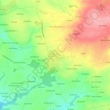
Name: Topografische Karte Kerouman, Höhe, Relief.
Durchschnittliche Höhe: 74 m
Minimale Höhe: 16 m
Maximale Höhe: 138 m
Andere topografische Karten
Klicken Sie auf eine Karte, um ihre Topografie, ihre Höhe und ihr Relief anzuzeigen.
Kerhornou
France > Brittany > Finistère > Ploumoguer
Kerhornou, Ploumoguer, Brest, Finistère, Brittany, Metropolitan France, 29810, France
Durchschnittliche Höhe: 35 m
Hameau de Bel Air
France > Brittany > Finistère > Ploumoguer
Hameau de Bel Air, Ploumoguer, Brest, Finistère, Brittany, Metropolitan France, 29810, France
Durchschnittliche Höhe: 73 m