
Topografische Karte Gorfolí
Interaktive Karte
Klicken Sie auf die Karte, um die Höhe anzuzeigen.
Über diese Karte
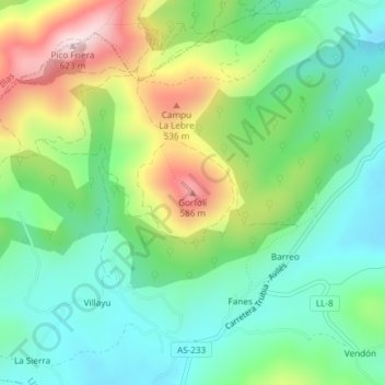
Name: Topografische Karte Gorfolí, Höhe, Relief.
Ort: Gorfolí, Llanera, Asturias, 33411, España (43.48095 -5.93137 43.48105 -5.93127)
Durchschnittliche Höhe: 345 m
Minimale Höhe: 211 m
Maximale Höhe: 607 m
Andere topografische Karten
Klicken Sie auf eine Karte, um ihre Topografie, ihre Höhe und ihr Relief anzuzeigen.
Santolaya / Soto de Llanera
España > Asturias > Llanera > Santolaya / Soto de Llanera
Santolaya / Soto de Llanera, Llanera, Asturias, 33423, España
Durchschnittliche Höhe: 203 m
Posada de Llanera
Posada de Llanera, Llanera, Asturias, 33424, España
Durchschnittliche Höhe: 207 m
Prubia
España > Asturias > Llanera > Santolaya / Soto de Llanera > Prubia de Abajo
Prubia, Prubia de Abajo, Santolaya / Soto de Llanera, Llanera, Asturias, 33423, España
Durchschnittliche Höhe: 198 m