
Topografische Karte Benicarló
Interaktive Karte
Klicken Sie auf die Karte, um die Höhe anzuzeigen.
Über diese Karte
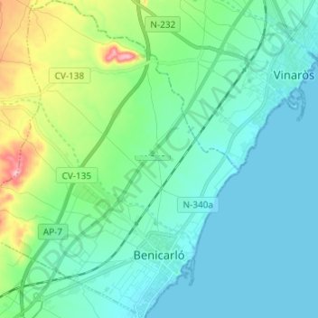
Name: Topografische Karte Benicarló, Höhe, Relief.
Durchschnittliche Höhe: 33 m
Minimale Höhe: -1 m
Maximale Höhe: 165 m
Andere topografische Karten
Klicken Sie auf eine Karte, um ihre Topografie, ihre Höhe und ihr Relief anzuzeigen.
Albenc
Espagne > Communauté Valencienne > Castellón > Vall d'Alba
Albenc, Vall d'Alba, la Plana Alta, Castellón, Communauté Valencienne, 12194, Espagne
Durchschnittliche Höhe: 287 m
Almassora
Espagne > Communauté Valencienne > Castellón
Almassora, la Plana Alta, Castellón, Communauté Valencienne, Espagne
Durchschnittliche Höhe: 32 m
la Torre de la Sal
Espagne > Communauté Valencienne > Castellón > Cabanes
la Torre de la Sal, Cabanes, la Plana Alta, Castellón, Communauté Valencienne, 12595, Espagne
Durchschnittliche Höhe: 4 m
Morella La Vella
Espagne > Communauté Valencienne > Castellón > Morella
Morella La Vella, Morella, els Ports, Castellón, Communauté Valencienne, 12300, Espagne
Durchschnittliche Höhe: 914 m
Almedíjar
Espagne > Communauté Valencienne > Castellón
Almedíjar, l'Alt Palància, Castellón, Communauté Valencienne, 12413, Espagne
Durchschnittliche Höhe: 512 m
Alcossebre
Espagne > Communauté Valencienne > Castellón
Alcossebre, Alcalà de Xivert, el Baix Maestrat, Castellón, Communauté Valencienne, 12579, Espagne
Durchschnittliche Höhe: 40 m
Cirat
Espagne > Communauté Valencienne > Castellón
Cirat, l'Alt Millars, Castellón, Communauté Valencienne, Espagne
Durchschnittliche Höhe: 649 m
Orpesa / Oropesa del Mar
Espagne > Communauté Valencienne > Castellón > Orpesa / Oropesa del Mar
Orpesa / Oropesa del Mar, la Plana Alta, Castellón, Communauté Valencienne, Espagne
Durchschnittliche Höhe: 64 m
Cinctorres
Espagne > Communauté Valencienne > Castellón > Cinctorres
Cinctorres, els Ports, Castellón, Communauté Valencienne, 12318, Espagne
Durchschnittliche Höhe: 942 m
Figueroles
Espagne > Communauté Valencienne > Castellón > Figueroles
Figueroles, l'Alcalatén, Castellón, Communauté Valencienne, Espagne
Durchschnittliche Höhe: 519 m
Peníscola / Peñíscola
Espagne > Communauté Valencienne > Castellón
Peníscola / Peñíscola, el Baix Maestrat, Castellón, Communauté Valencienne, Espagne
Durchschnittliche Höhe: 51 m
Fredes
Espagne > Communauté Valencienne > Castellón > la Pobla de Benifassà
Fredes, la Pobla de Benifassà, el Baix Maestrat, Castellón, Communauté Valencienne, 12599, Espagne
Durchschnittliche Höhe: 1.092 m
la Vall d'Uixó
Espagne > Communauté Valencienne > Castellón > la Vall d'Uixó > la Vall d'Uixó
la Vall d'Uixó, la Plana Baixa, Castellón, Communauté Valencienne, 12600, Espagne
Durchschnittliche Höhe: 196 m
San Rafael del Río
Espagne > Communauté Valencienne > Castellón > San Rafael del Río
San Rafael del Río, el Baix Maestrat, Castellón, Communauté Valencienne, 12510, Espagne
Durchschnittliche Höhe: 224 m
Benicàssim / Benicasim
Espagne > Communauté Valencienne > Castellón > Benicàssim / Benicasim > Benicàssim / Benicasim
Benicàssim / Benicasim, la Plana Alta, Castellón, Communauté Valencienne, 12560, Espagne
Durchschnittliche Höhe: 64 m
Castelló de la Plana
Espagne > Communauté Valencienne > Castellón
Castelló de la Plana, la Plana Alta, Castellón, Communauté Valencienne, Espagne
Durchschnittliche Höhe: 216 m
Benicàssim / Benicasim
Espagne > Communauté Valencienne > Castellón
Benicàssim / Benicasim, la Plana Alta, Castellón, Communauté Valencienne, 12560, Espagne
Durchschnittliche Höhe: 107 m
Alcalà de Xivert
Espagne > Communauté Valencienne > Castellón > Alcalà de Xivert
Alcalà de Xivert, el Baix Maestrat, Castellón, Communauté Valencienne, Espagne
Durchschnittliche Höhe: 197 m
Segorbe
Espagne > Communauté Valencienne > Castellón
Segorbe, l'Alt Palància, Castellón, Communauté Valencienne, 12400, Espagne
Durchschnittliche Höhe: 485 m
Argelita
Espagne > Communauté Valencienne > Castellón
Argelita, l'Alt Millars, Castellón, Communauté Valencienne, Espagne
Durchschnittliche Höhe: 572 m
Vila-real
Espagne > Communauté Valencienne > Castellón
Vila-real, la Plana Baixa, Castellón, Communauté Valencienne, 12540, Espagne
Durchschnittliche Höhe: 42 m
Sot de Ferrer
Espagne > Communauté Valencienne > Castellón
Sot de Ferrer, l'Alt Palància, Castellón, Communauté Valencienne, 12489, Espagne
Durchschnittliche Höhe: 272 m
la Vall d'Uixó
Espagne > Communauté Valencienne > Castellón
la Vall d'Uixó, la Plana Baixa, Castellón, Communauté Valencienne, 12600, Espagne
Durchschnittliche Höhe: 190 m