
Topografische Karte Choptank
Interaktive Karte
Klicken Sie auf die Karte, um die Höhe anzuzeigen.
Über diese Karte
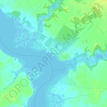
Name: Topografische Karte Choptank, Höhe, Relief.
Ort: Choptank, Caroline County, Maryland, United States (38.66095 -75.96827 38.70095 -75.92827)
Durchschnittliche Höhe: 5 m
Minimale Höhe: -2 m
Maximale Höhe: 17 m
Andere topografische Karten
Klicken Sie auf eine Karte, um ihre Topografie, ihre Höhe und ihr Relief anzuzeigen.
Ridgely
United States > Maryland > Caroline County
Ridgely, Caroline County, Maryland, 21660, United States
Durchschnittliche Höhe: 18 m
Pealiquor Landing
United States > Maryland > Caroline County
Pealiquor Landing, Caroline County, Maryland, 21629, United States
Durchschnittliche Höhe: 10 m
Federalsburg Estates
United States > Maryland > Caroline County
Federalsburg Estates, Caroline County, Maryland, United States
Durchschnittliche Höhe: 15 m
Federalsburg
United States > Maryland > Caroline County
Federalsburg, Caroline County, Maryland, United States
Durchschnittliche Höhe: 10 m
Lynn Woods
United States > Maryland > Caroline County > Lynn Woods
Lynn Woods, Caroline County, Maryland, United States
Durchschnittliche Höhe: 16 m