
Topografische Karte Morris County
Interaktive Karte
Klicken Sie auf die Karte, um die Höhe anzuzeigen.
Über diese Karte
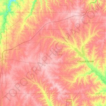
Name: Topografische Karte Morris County, Höhe, Relief.
Ort: Morris County, Kansas, United States (38.52154 -96.93392 38.87035 -96.35261)
Durchschnittliche Höhe: 428 m
Minimale Höhe: 339 m
Maximale Höhe: 477 m
Andere topografische Karten
Klicken Sie auf eine Karte, um ihre Topografie, ihre Höhe und ihr Relief anzuzeigen.
Topeka
United States > Kansas > Shawnee County
Topeka, Shawnee County, Kansas, United States
Durchschnittliche Höhe: 302 m
Johnson County
Johnson County, Kansas, United States
Durchschnittliche Höhe: 297 m
Wichita
United States > Kansas > Sedgwick County
Wichita, Sedgwick County, Kansas, United States
Durchschnittliche Höhe: 408 m
Dodge City
United States > Kansas > Ford County
Dodge City, Ford County, Kansas, 67801, United States
Durchschnittliche Höhe: 777 m
Tonganoxie
United States > Kansas > Leavenworth County
Tonganoxie, Leavenworth County, Kansas, 66086, United States
Durchschnittliche Höhe: 283 m
Lawrence
United States > Kansas > Douglas County
Lawrence, Douglas County, Kansas, United States
Durchschnittliche Höhe: 265 m
Hays
United States > Kansas > Ellis County
Hays, Ellis County, Kansas, 67601, United States
Durchschnittliche Höhe: 624 m
Albany Hill
United States > Kansas > Nemaha County
Albany Hill, Nemaha County, Kansas, United States
Durchschnittliche Höhe: 377 m
Ransom
United States > Kansas > Ness County
Ransom, Ness County, Kansas, 67572, United States
Durchschnittliche Höhe: 767 m
Douglas County
Douglas County, Kansas, United States
Durchschnittliche Höhe: 294 m
Westwood Hills
United States > Kansas > Johnson County
Westwood Hills, Johnson County, Kansas, United States
Durchschnittliche Höhe: 286 m
Decatur County
Decatur County, Kansas, United States
Durchschnittliche Höhe: 816 m
Russell County
Russell County, Kansas, United States
Durchschnittliche Höhe: 539 m
Seward County
Seward County, Kansas, United States
Durchschnittliche Höhe: 866 m
Anderson County
Anderson County, Kansas, United States
Durchschnittliche Höhe: 320 m
Grant County
Grant County, Kansas, 67880, United States
Durchschnittliche Höhe: 934 m
Coffey County
Coffey County, Kansas, United States
Durchschnittliche Höhe: 338 m
Sheridan County
Sheridan County, Kansas, United States
Durchschnittliche Höhe: 840 m
Wichita County
Wichita County, Kansas, United States
Durchschnittliche Höhe: 1.004 m
Glasco
United States > Kansas > Cloud County
Glasco, Cloud County, Kansas, 67445, United States
Durchschnittliche Höhe: 405 m
Tribune Township
United States > Kansas > Greeley County
Tribune Township, Greeley County, Kansas, 67879, United States
Durchschnittliche Höhe: 1.119 m
Prairie Highlands
United States > Kansas > Johnson County > Olathe
Prairie Highlands, Olathe, Johnson County, Kansas, 66031, United States
Durchschnittliche Höhe: 314 m
Wyandotte County
Wyandotte County, Kansas, United States
Durchschnittliche Höhe: 274 m
Norton
United States > Kansas > Norton County
Norton, Norton County, Kansas, 67654, United States
Durchschnittliche Höhe: 704 m
Lemon Park
United States > Kansas > Pratt County > Pratt
Lemon Park, Pratt, Pratt County, Kansas, United States
Durchschnittliche Höhe: 572 m
Hoxie
United States > Kansas > Sheridan County
Hoxie, Sheridan County, Kansas, 67740, United States
Durchschnittliche Höhe: 821 m
New Almelo
United States > Kansas > Norton County
New Almelo, Norton County, Kansas, United States
Durchschnittliche Höhe: 743 m
Alta Vista
United States > Kansas > Wabaunsee County
Alta Vista, Wabaunsee County, Kansas, United States
Durchschnittliche Höhe: 443 m
Angelus
United States > Kansas > Sheridan County
Angelus, Sheridan County, Kansas, United States
Durchschnittliche Höhe: 887 m
Oberlin
United States > Kansas > Decatur County
Oberlin, Decatur County, Kansas, 67749, United States
Durchschnittliche Höhe: 794 m
Seguin
United States > Kansas > Sheridan County
Seguin, Sheridan County, Kansas, United States
Durchschnittliche Höhe: 870 m
Almena
United States > Kansas > Norton County
Almena, Norton County, Kansas, 67622, United States
Durchschnittliche Höhe: 663 m
Dresden
United States > Kansas > Decatur County
Dresden, Decatur County, Kansas, 67635, United States
Durchschnittliche Höhe: 828 m
Sawyer
United States > Kansas > Pratt County
Sawyer, Pratt County, Kansas, United States
Durchschnittliche Höhe: 582 m
Plymell
United States > Kansas > Finney County
Plymell, Finney County, Kansas, United States
Durchschnittliche Höhe: 878 m
Holcomb
United States > Kansas > Finney County
Holcomb, Finney County, Kansas, United States
Durchschnittliche Höhe: 879 m
Jennings
United States > Kansas > Decatur County
Jennings, Decatur County, Kansas, 67643, United States
Durchschnittliche Höhe: 769 m
Leoville
United States > Kansas > Decatur County
Leoville, Decatur County, Kansas, United States
Durchschnittliche Höhe: 842 m
Russell
United States > Kansas > Russell County
Russell, Russell County, Kansas, United States
Durchschnittliche Höhe: 561 m
Oskaloosa
United States > Kansas > Jefferson County
Oskaloosa, Jefferson County, Kansas, United States
Durchschnittliche Höhe: 329 m
Paxico
United States > Kansas > Wabaunsee County
Paxico, Wabaunsee County, Kansas, 66526, United States
Durchschnittliche Höhe: 310 m
Volland
United States > Kansas > Wabaunsee County
Volland, Wabaunsee County, Kansas, United States
Durchschnittliche Höhe: 387 m
New Cambria
United States > Kansas > Saline County
New Cambria, Saline County, Kansas, United States
Durchschnittliche Höhe: 364 m
McFarland
United States > Kansas > Wabaunsee County
McFarland, Wabaunsee County, Kansas, 66501, United States
Durchschnittliche Höhe: 320 m
Gorham
United States > Kansas > Russell County
Gorham, Russell County, Kansas, United States
Durchschnittliche Höhe: 582 m
Maywood
United States > Kansas > Leavenworth County > Leavenworth
Maywood, Leavenworth, Leavenworth County, Kansas, 64092, United States
Durchschnittliche Höhe: 246 m