
Topografische Karte Denpasar
Interaktive Karte
Klicken Sie auf die Karte, um die Höhe anzuzeigen.
Über diese Karte
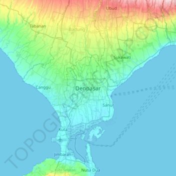
Name: Topografische Karte Denpasar, Höhe, Relief.
Durchschnittliche Höhe: 48 m
Minimale Höhe: -1 m
Maximale Höhe: 315 m
Denpasar is located at an elevation of 4 m (13 ft) above sea level. While the total area of 125.98 km2 or 2.18% of the total area of Bali Province. From the use of land, 2,768 hectares of land are paddy, 10,001 hectares are dry land, while the remaining land area is 9 hectares.