
Topografische Karte Millau
Interaktive Karte
Klicken Sie auf die Karte, um die Höhe anzuzeigen.
Über diese Karte
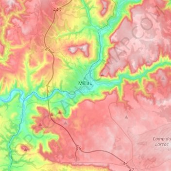
Name: Topografische Karte Millau, Höhe, Relief.
Ort: Millau, Aveyron, Occitania, Metropolitan France, 12100, France (44.01667 2.99064 44.17985 3.24486)
Durchschnittliche Höhe: 656 m
Minimale Höhe: 331 m
Maximale Höhe: 895 m
The territory of this town lies across a southern portion of the Massif Central. It covers a large area of some 16,823 hectares (41,570 acres), which makes it the 25th largest metropolitan town in France. The municipality lies at the heart of the Grands Causses, a part of the Causse Rouge (east of the plateau Lévézou), and part of Larzac as well as part of the Black Causse. The city county seat is located in the lower part of the town, in a large depression at the confluence of the Tarn and Dourbie, at an altitude of about 340 m.
Andere topografische Karten
Klicken Sie auf eine Karte, um ihre Topografie, ihre Höhe und ihr Relief anzuzeigen.
Villefranche-de-Rouergue
Villefranche-de-Rouergue, Aveyron, Occitania, Metropolitan France, 12200, France
Durchschnittliche Höhe: 389 m
Conques-en-Rouergue
Conques-en-Rouergue, Rodez, Aveyron, Occitania, Metropolitan France, 12320, France
Durchschnittliche Höhe: 415 m
Saint-Côme-d'Olt
Saint-Côme-d'Olt, Rodez, Aveyron, Occitania, Metropolitan France, 12500, France
Durchschnittliche Höhe: 546 m
Les Faisses
France > Occitania > Aveyron > Saint-Beauzély
Les Faisses, Saint-Beauzély, Millau, Aveyron, Occitania, Metropolitan France, 12620, France
Durchschnittliche Höhe: 735 m
Prades-d'Aubrac
Prades-d'Aubrac, Rodez, Aveyron, Occitania, Metropolitan France, 12470, France
Durchschnittliche Höhe: 836 m
Liaucous
France > Occitania > Aveyron > Mostuéjouls
Liaucous, Mostuéjouls, Millau, Aveyron, Occitania, Metropolitan France, 12720, France
Durchschnittliche Höhe: 612 m
Villevayre
France > Occitania > Aveyron > Najac
Villevayre, Najac, Villefranche-de-Rouergue, Aveyron, Occitania, Metropolitan France, 12270, France
Durchschnittliche Höhe: 378 m
Agen-d'Aveyron
Agen-d'Aveyron, Millau, Aveyron, Occitania, Metropolitan France, 12630, France
Durchschnittliche Höhe: 672 m
Livinhac-le-Haut
Livinhac-le-Haut, Villefranche-de-Rouergue, Aveyron, Occitania, Metropolitan France, 12300, France
Durchschnittliche Höhe: 283 m
Agnac
France > Occitania > Aveyron > Druelle Balsac
Agnac, Druelle Balsac, Rodez, Aveyron, Occitania, Metropolitan France, 12510, France
Durchschnittliche Höhe: 581 m
Saint-Chély-d'Aubrac
Saint-Chély-d'Aubrac, Rodez, Aveyron, Occitania, Metropolitan France, 12470, France
Durchschnittliche Höhe: 991 m
Saint-Beaulize
France > Occitania > Aveyron > Saint-Beaulize
Saint-Beaulize, Millau, Aveyron, Occitania, Metropolitan France, 12540, France
Durchschnittliche Höhe: 695 m
Palmas
France > Occitania > Aveyron > Palmas d'Aveyron
Palmas, Palmas d'Aveyron, Rodez, Aveyron, Occitania, Metropolitan France, 12310, France
Durchschnittliche Höhe: 613 m
La Bastide-Solages
La Bastide-Solages, Millau, Aveyron, Occitania, Metropolitan France, 12550, France
Durchschnittliche Höhe: 388 m