
Topografische Karte Martindale
Interaktive Karte
Klicken Sie auf die Karte, um die Höhe anzuzeigen.
Über diese Karte
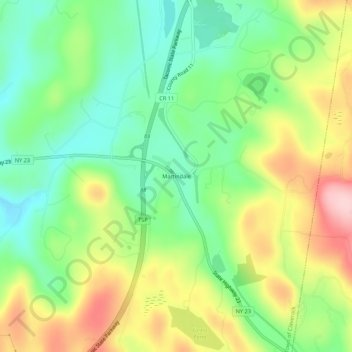
Name: Topografische Karte Martindale, Höhe, Relief.
Durchschnittliche Höhe: 229 m
Minimale Höhe: 145 m
Maximale Höhe: 355 m
Andere topografische Karten
Klicken Sie auf eine Karte, um ihre Topografie, ihre Höhe und ihr Relief anzuzeigen.
Mellenville
United States > New York > Columbia County > Town of Claverack
Mellenville, Town of Claverack, Columbia County, New York, 12544, United States
Durchschnittliche Höhe: 114 m
Churchtown
United States > New York > Columbia County > Town of Claverack
Churchtown, Town of Claverack, Columbia County, New York, 12530, United States
Durchschnittliche Höhe: 119 m
Hollowville
United States > New York > Columbia County > Town of Claverack
Hollowville, Town of Claverack, Columbia County, New York, 12530, United States
Durchschnittliche Höhe: 135 m
Upper Hollowville
United States > New York > Columbia County > Town of Claverack
Upper Hollowville, Town of Claverack, Columbia County, New York, 12530, United States
Durchschnittliche Höhe: 190 m
Red Mills
United States > New York > Columbia County > Town of Claverack
Red Mills, Town of Claverack, Columbia County, New York, 12513, United States
Durchschnittliche Höhe: 81 m
Brick Tavern
United States > New York > Columbia County > Town of Claverack
Brick Tavern, Town of Claverack, Columbia County, New York, 12172, United States
Durchschnittliche Höhe: 60 m
Village of Philmont
United States > New York > Columbia County > Town of Claverack
Village of Philmont, Town of Claverack, Columbia County, New York, 12565, United States
Durchschnittliche Höhe: 145 m