
Topografische Karte Penguin Island
Interaktive Karte
Klicken Sie auf die Karte, um die Höhe anzuzeigen.
Über diese Karte
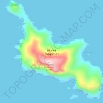
Name: Topografische Karte Penguin Island, Höhe, Relief.
Durchschnittliche Höhe: 48 m
Minimale Höhe: 0 m
Maximale Höhe: 354 m
Andere topografische Karten
Klicken Sie auf eine Karte, um ihre Topografie, ihre Höhe und ihr Relief anzuzeigen.
Pointe Goodenough
France > French Southern and Antarctic Lands
Pointe Goodenough, New Amsterdam Island, Saint Paul and New Amsterdam Islands, French Southern and Antarctic Lands, France
Durchschnittliche Höhe: 40 m
Mont Pâris
France > French Southern and Antarctic Lands
Mont Pâris, Kerguelen Archipelago, French Southern and Antarctic Lands, France
Durchschnittliche Höhe: 255 m
Possession Island
France > French Southern and Antarctic Lands
Possession Island, French Southern and Antarctic Lands, France
Durchschnittliche Höhe: 13 m
New Amsterdam Island
France > French Southern and Antarctic Lands
New Amsterdam Island, Saint Paul and New Amsterdam Islands, French Southern and Antarctic Lands, France
Durchschnittliche Höhe: 186 m
Cataractes
France > French Southern and Antarctic Lands
Cataractes, Kerguelen Archipelago, French Southern and Antarctic Lands, France
Durchschnittliche Höhe: 31 m
Crozet Archipelago
France > French Southern and Antarctic Lands
Crozet Archipelago, French Southern and Antarctic Lands, France
Durchschnittliche Höhe: 2 m
Bassas da India
France > French Southern and Antarctic Lands
Bassas da India, Scattered Islands in the Indian Ocean, French Southern and Antarctic Lands, France
Durchschnittliche Höhe: 0 m
Kerguelen Archipelago
France > French Southern and Antarctic Lands
Kerguelen Archipelago, French Southern and Antarctic Lands, France
Durchschnittliche Höhe: 38 m