
Topografische Karte Darwen
Klicken Sie auf die Karte, um die Höhe anzuzeigen.
Darwen
Much of the town was built between about 1850 and 1900; placenames, date stones in terraces, and the vernacular architecture of cellars, local stone, locally-made brick, pipework and tiles and leaded glass, the last now mostly gone, reflect this. It was one of the first places in the world to have steam trams. The arrangement of town hall, market, public transport, eating/hotel facilities and the pre-suburban mixed-size vernacular housing, with local variations according to topography, is very characteristic of Northern England. The year 1900 perhaps represents the peak of Victorian optimism in the area. The working classes were then much more identifiable as masses than now. The rise of the Labour Party from about 1900 coincided with a decline in the Liberal Party, which followed the Manchester School in economics, increasingly seen as permitting unjustified exploitation. However, Darwen usually voted for the Conservative Party until a Conservative government made unpopular administrative rearrangements in the early 1970s.
Über diese Karte
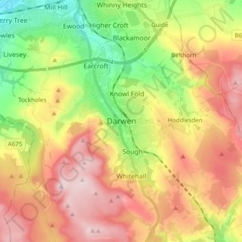
Name: Topografische Karte Darwen, Höhe, Relief.
Durchschnittliche Höhe: 241 m
Minimale Höhe: 85 m
Maximale Höhe: 402 m