
Topografische Karte Molinete
Interaktive Karte
Klicken Sie auf die Karte, um die Höhe anzuzeigen.
Über diese Karte
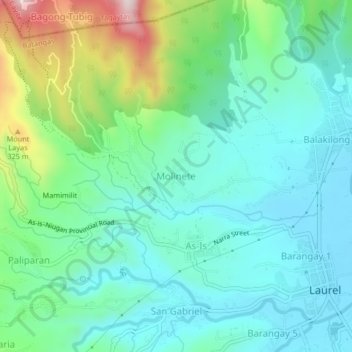
Name: Topografische Karte Molinete, Höhe, Relief.
Ort: Molinete, Laurel, Batangas, Calabarzon, 4221, Philippines (14.04342 120.89573 14.08342 120.93573)
Durchschnittliche Höhe: 122 m
Minimale Höhe: 5 m
Maximale Höhe: 477 m
Andere topografische Karten
Klicken Sie auf eine Karte, um ihre Topografie, ihre Höhe und ihr Relief anzuzeigen.
Barangay 3
Philippines > Batangas > Laurel
Barangay 3, Laurel, Batangas, Calabarzon, 4221, Philippines
Durchschnittliche Höhe: 33 m
Mamimilit
Philippines > Batangas > Laurel > Paliparan
Mamimilit, Paliparan, Laurel, Batangas, Calabarzon, 4221, Philippines
Durchschnittliche Höhe: 192 m
Dayap Itaas
Philippines > Batangas > Laurel
Dayap Itaas, Laurel, Batangas, Calabarzon, Philippines
Durchschnittliche Höhe: 503 m