
Topografische Karte Serra da Estrela Nature Park
Interaktive Karte
Klicken Sie auf die Karte, um die Höhe anzuzeigen.
Serra da Estrela Nature Park
Serra da Estrela Natural Park is situated in the largest mountain range in Portugal - the Serra da Estrela, and is the source of the rivers Mondego, Zêzere (tributary of the Tagus), and Alva. The park is the largest natural conservation area in Portugal and occupies about 1,000 km2. More than half of its area is located above an altitude of 700 m. At 1,993 m it contains the highest peak in Continental Portugal (named Torre) and a ski resort (named Vodafone Ski Resort).
Über diese Karte
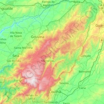
Name: Topografische Karte Serra da Estrela Nature Park, Höhe, Relief.
Durchschnittliche Höhe: 740 m
Minimale Höhe: 198 m
Maximale Höhe: 1.989 m