
Topografische Karte Lake Granby
Interaktive Karte
Klicken Sie auf die Karte, um die Höhe anzuzeigen.
Über diese Karte
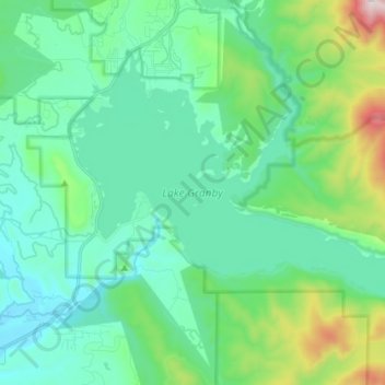
Name: Topografische Karte Lake Granby, Höhe, Relief.
Ort: Lake Granby, Grand County, Colorado, United States (40.11471 -105.90010 40.19421 -105.75684)
Durchschnittliche Höhe: 2.608 m
Minimale Höhe: 2.418 m
Maximale Höhe: 3.344 m
Andere topografische Karten
Klicken Sie auf eine Karte, um ihre Topografie, ihre Höhe und ihr Relief anzuzeigen.
Winter Park
United States > Colorado > Grand County
Winter Park, Grand County, Colorado, United States
Durchschnittliche Höhe: 3.068 m
Tabernash
United States > Colorado > Grand County > Tabernash
Tabernash, Grand County, Colorado, United States
Durchschnittliche Höhe: 2.593 m
Taylor Peak
United States > Colorado > Grand County
Taylor Peak, Grand County, Colorado, United States
Durchschnittliche Höhe: 3.646 m
Fraser
United States > Colorado > Grand County
Fraser, Grand County, Colorado, 80442, United States
Durchschnittliche Höhe: 2.696 m
Granby
United States > Colorado > Grand County
Granby, Grand County, Colorado, United States
Durchschnittliche Höhe: 2.555 m
Rock Creek
United States > Colorado > Grand County
Rock Creek, Grand County, Colorado, United States
Durchschnittliche Höhe: 2.724 m