
Topografische Karte Singtam
Interaktive Karte
Klicken Sie auf die Karte, um die Höhe anzuzeigen.
Über diese Karte
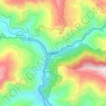
Name: Topografische Karte Singtam, Höhe, Relief.
Ort: Singtam, Gangtok district, Sikkim, 737134, India (27.19200 88.45708 27.27200 88.53708)
Durchschnittliche Höhe: 894 m
Minimale Höhe: 302 m
Maximale Höhe: 1.889 m
Singtam is located at 27°09′N 88°23′E / 27.15°N 88.38°E / 27.15; 88.38. It has an average elevation of 1396 feet. As the town lies on the bank of two rivers River Teesta and Ranikhola, so during Monsoon especially from June to September the volume of both the river increases heavily, as a result destruction is caused on the low lying areas of the town especially at Adarsh gaon and Jublee line part of the town.
Andere topografische Karten
Klicken Sie auf eine Karte, um ihre Topografie, ihre Höhe und ihr Relief anzuzeigen.
South Lhonak Glacier
India > Sikkim > Chungthang
South Lhonak Glacier, Chungthang, Mangan District, Sikkim, India
Durchschnittliche Höhe: 5.830 m
Goecha La Lake
Goecha La Lake, Mangan, Mangan District, Sikkim, India
Durchschnittliche Höhe: 4.953 m
Pakyong
India > Sikkim > Pakyong subdivision
Pakyong, Pakyong subdivision, Pakyong District, Sikkim, 737106, India
Durchschnittliche Höhe: 1.235 m
North Sikkim District
North Sikkim District, Sikkim, India
Durchschnittliche Höhe: 4.407 m
West Sikkim District
West Sikkim District, Sikkim, India
Durchschnittliche Höhe: 2.686 m
Chungthang
Chungthang, North Sikkim District, Sikkim, 737120, India
Durchschnittliche Höhe: 4.598 m
East Sikkim District
East Sikkim District, Sikkim, India
Durchschnittliche Höhe: 2.107 m
Lachung Chu
India > Sikkim > Chungthang > Lachung
Lachung Chu, Lachung, Chungthang, North Sikkim District, Sikkim, India
Durchschnittliche Höhe: 4.332 m
North District
North District, North Sikkim District, Sikkim, India
Durchschnittliche Höhe: 3.760 m
Lower Sichey
Lower Sichey, Gangtok, East Sikkim District, Sikkim, India
Durchschnittliche Höhe: 1.352 m
West District
India > Sikkim > West District
West District, West Sikkim District, Sikkim, 737111, India
Durchschnittliche Höhe: 2.636 m
South Sikkim District
South Sikkim District, Sikkim, India
Durchschnittliche Höhe: 1.774 m
East District
India > Sikkim > East District
East District, East Sikkim District, Sikkim, India
Durchschnittliche Höhe: 2.740 m
Lachung
India > Sikkim > Chungthang
Lachung, Chungthang, Mangan District, Sikkim, India
Durchschnittliche Höhe: 3.617 m
Western Sikkim Subsection
Western Sikkim Subsection, North District, North Sikkim District, Sikkim, India
Durchschnittliche Höhe: 3.898 m
Upper Sichey
Upper Sichey, Gangtok, East Sikkim District, Sikkim, India
Durchschnittliche Höhe: 1.459 m
Lower M G Marg
Lower M G Marg, Gangtok, East Sikkim District, Sikkim, 737101, India
Durchschnittliche Höhe: 1.348 m
Teesta River
Teesta River, Namchi, South Sikkim District, Sikkim, 737132, India
Durchschnittliche Höhe: 1.113 m
Pegong
India > Sikkim > Chungthang
Pegong, Chungthang, North Sikkim District, Sikkim, India
Durchschnittliche Höhe: 1.950 m
Gurudongmar
India > Sikkim > Chungthang
Gurudongmar, Chungthang, North Sikkim District, Sikkim, India
Durchschnittliche Höhe: 5.232 m
South District
India > Sikkim > South District
South District, South Sikkim District, Sikkim, 737139, India
Durchschnittliche Höhe: 2.687 m
Zemu Glacier
Zemu Glacier, North District, North Sikkim District, Sikkim, India
Durchschnittliche Höhe: 5.499 m
Khecheopalri Lake
Khecheopalri Lake, MDR, Yuksom, West District, West Sikkim District, Sikkim, 737113, India
Durchschnittliche Höhe: 1.798 m
Tso Lhamo Lake
Tso Lhamo Lake, North District, North Sikkim District, Sikkim, India
Durchschnittliche Höhe: 5.146 m