
Topografische Karte Los Molinos
Interaktive Karte
Klicken Sie auf die Karte, um die Höhe anzuzeigen.
Über diese Karte
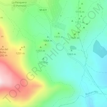
Name: Topografische Karte Los Molinos, Höhe, Relief.
Durchschnittliche Höhe: 1.120 m
Minimale Höhe: 971 m
Maximale Höhe: 1.431 m
Andere topografische Karten
Klicken Sie auf eine Karte, um ihre Topografie, ihre Höhe und ihr Relief anzuzeigen.
La Encinilla
España > Comunidad de Madrid > Bustarviejo
La Encinilla, Bustarviejo, Comunidad de Madrid, 28792, España
Durchschnittliche Höhe: 1.258 m
Cancho del Mondalindo
España > Comunidad de Madrid > Bustarviejo
Cancho del Mondalindo, Bustarviejo, Sierra Norte, Comunidad de Madrid, 28720, España
Durchschnittliche Höhe: 1.442 m