
Topografische Karte Adama
Interaktive Karte
Klicken Sie auf die Karte, um die Höhe anzuzeigen.
Über diese Karte
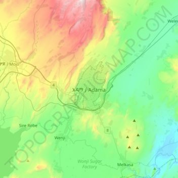
Name: Topografische Karte Adama, Höhe, Relief.
Ort: Adama, East Shewa, Oromia Region, 36, Ethiopia (8.38103 39.11055 8.70103 39.43055)
Durchschnittliche Höhe: 1.673 m
Minimale Höhe: 1.340 m
Maximale Höhe: 2.447 m
Adama (Oromo: Adaamaa or Hadaamaa), officially known as Adaamaa and formerly Nazareth (Amharic: ናዝሬት), is a city in central Oromia Region, Ethiopia. Adama forms a Special Zone of Oromia and is surrounded by East Shewa Zone. It is located at 8°32′N 39°16′E / 8.54°N 39.27°E / 8.54; 39.27 at an elevation of 1712 meters, 99 km southeast of Oromia's Addis Ababa. The city sits between the base of an escarpment to the west, and the Great Rift Valley to the east.