
Topografische Karte Claremont Canyon
Interaktive Karte
Klicken Sie auf die Karte, um die Höhe anzuzeigen.
Über diese Karte
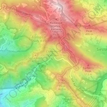
Name: Topografische Karte Claremont Canyon, Höhe, Relief.
Durchschnittliche Höhe: 367 m
Minimale Höhe: 137 m
Maximale Höhe: 570 m
Andere topografische Karten
Klicken Sie auf eine Karte, um ihre Topografie, ihre Höhe und ihr Relief anzuzeigen.
Reinhardt-Redwood Regional Park
United States > California > Alameda County > Oakland
Reinhardt-Redwood Regional Park, Serpentine Prairie Trail, Oakland Hills, Oakland, Alameda County, CAL Fire Northern Region, California, 94615, United States
Durchschnittliche Höhe: 292 m
Allendale Park
United States > California > Alameda County > Oakland
Allendale Park, Laurel, Oakland, Alameda County, CAL Fire Northern Region, California, United States
Durchschnittliche Höhe: 59 m
Dunsmuir Reservoir 31-018 Dam
United States > California > Alameda County > Oakland
Dunsmuir Reservoir 31-018 Dam, Oakland, Alameda County, California, 94577, United States
Durchschnittliche Höhe: 80 m