
Topografische Karte Mount Erciyes
Interaktive Karte
Klicken Sie auf die Karte, um die Höhe anzuzeigen.
Über diese Karte
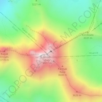
Name: Topografische Karte Mount Erciyes, Höhe, Relief.
Durchschnittliche Höhe: 3.329 m
Minimale Höhe: 2.878 m
Maximale Höhe: 3.896 m
The climate of the region is influenced by topography, with the Taurus and Kaçkar Mountains blocking the entry of moisture into Anatolia. Summers are dry and hot and winters wet and cold; in Kayseri, summer temperatures are about 19 °C (66 °F) and winter temperature about 0 °C (32 °F). Precipitation at Kayseri falls mostly in autumn, winter, and spring and amounts to 383 millimetres (15.1 in) per year. In Develi, south of Erciyes, maximum temperatures are about 29.5 °C (85.1 °F) and minimum temperatures −5.6 °C (21.9 °F). Estimated temperatures at 2,700 metres (8,900 ft) altitude are about −0.4 °C (31.3 °F), and precipitation 722 millimetres (28.4 in) per year. During the last glacial maximum, precipitation may have been double that of present-day.
Andere topografische Karten
Klicken Sie auf eine Karte, um ihre Topografie, ihre Höhe und ihr Relief anzuzeigen.