
Spenden
Rüsten Sie sich für Ihr nächstes Abenteuer:
Als Amazon-Partner verdient diese Website an qualifizierten Käufen, ohne dass Ihnen zusätzliche Kosten entstehen.
Topografische Karte Sierra Vista
Klicken Sie auf die Karte, um die Höhe anzuzeigen.
Spenden
Rüsten Sie sich für Ihr nächstes Abenteuer:
Als Amazon-Partner verdient diese Website an qualifizierten Käufen, ohne dass Ihnen zusätzliche Kosten entstehen.
Sierra Vista
In the Köppen climate classification system, Sierra Vista falls within the typical cold semi-arid climate (BSk) of mid-altitude Arizona. Fall and spring, like most other parts of Arizona, are very dry. Winters are cool to cold with frosts which can occasionally be hard freezes; frost can be expected to stop in mid- to late April. Spring, like fall, spends about half of itself within the frost season. Summer starts off dry, but progressively gets wetter as the monsoon season approaches. The city has a fairly stable climate with very little humidity. However, the North American Monsoon can bring torrential rains during the months of July and August and will produce almost half the yearly rainfall in just those two months alone. Due to the dry climate the rest of the year and the city's high elevation, daily winter low temperatures range from 20 to 30 °F (−6.7 to −1.1 °C) on average and up to 50 °F (10.0 °C) on rare occasions when moist fronts bring warm air from the Gulf of California. Snow is not a common sight on the streets of Sierra Vista though some years the city can receive several inches of snow and other years it will receive none. However, a snow-capped Miller Peak and Carr Peak in the Huachuca Mountains is a common sight for four to five months every year.
Spenden
Rüsten Sie sich für Ihr nächstes Abenteuer:
Als Amazon-Partner verdient diese Website an qualifizierten Käufen, ohne dass Ihnen zusätzliche Kosten entstehen.
Über diese Karte
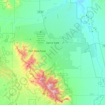
Name: Topografische Karte Sierra Vista, Höhe, Relief.
Ort: Sierra Vista, Cochise County, Arizona, United States (31.34778 -110.44915 31.68679 -110.09806)
Durchschnittliche Höhe: 1.513 m
Minimale Höhe: 1.188 m
Maximale Höhe: 2.867 m
Spenden
Rüsten Sie sich für Ihr nächstes Abenteuer:
Als Amazon-Partner verdient diese Website an qualifizierten Käufen, ohne dass Ihnen zusätzliche Kosten entstehen.
Andere topografische Karten
Klicken Sie auf eine Karte, um ihre Topografie, ihre Höhe und ihr Relief anzuzeigen.
Willcox
United States > Arizona > Cochise County
Willcox's high elevation gives it a milder climate than the nearby Valley of the Sun and Sonoran Desert. It also receives more rainfall than Tucson and Phoenix due to the summer monsoon rains and thus it has a hot semi-arid climate (Koppen: BSh)
Durchschnittliche Höhe: 1.274 m
Spenden
Rüsten Sie sich für Ihr nächstes Abenteuer:
Als Amazon-Partner verdient diese Website an qualifizierten Käufen, ohne dass Ihnen zusätzliche Kosten entstehen.
Sierra Vista Estates
United States > Arizona > Cochise County > Sierra Vista
Durchschnittliche Höhe: 1.429 m
Spenden
Rüsten Sie sich für Ihr nächstes Abenteuer:
Als Amazon-Partner verdient diese Website an qualifizierten Käufen, ohne dass Ihnen zusätzliche Kosten entstehen.
Willcox
United States > Arizona > Cochise County
Willcox's high elevation gives it a milder climate than the nearby Valley of the Sun and Sonoran Desert. It also receives more rainfall than Tucson and Phoenix due to the summer monsoon rains and thus it has a hot semi-arid climate (Koppen: BSh).
Durchschnittliche Höhe: 1.274 m
Spenden
Rüsten Sie sich für Ihr nächstes Abenteuer:
Als Amazon-Partner verdient diese Website an qualifizierten Käufen, ohne dass Ihnen zusätzliche Kosten entstehen.
Bakerville
United States > Arizona > Cochise County > Bisbee > Warren
Bakerville is a populated place situated within the city of Bisbee in Cochise County, Arizona, United States. It has an estimated elevation of 5,039 feet (1,536 m) above sea level.
Durchschnittliche Höhe: 1.579 m