
Topografische Karte High Rolls
Interaktive Karte
Klicken Sie auf die Karte, um die Höhe anzuzeigen.
Über diese Karte
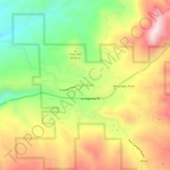
Name: Topografische Karte High Rolls, Höhe, Relief.
Ort: High Rolls, Otero County, New Mexico, 88325, United States (32.93092 -105.85554 32.97092 -105.81554)
Durchschnittliche Höhe: 2.036 m
Minimale Höhe: 1.756 m
Maximale Höhe: 2.322 m
The first official use of the High Rolls name was in 1901, when the post office was moved from Fresnal (Wooten) to High Rolls. The name, which was sometimes spelled as one word, Highrolls, supposedly came from the shape and elevation of the area as compared to the sharper peaks higher up.
Andere topografische Karten
Klicken Sie auf eine Karte, um ihre Topografie, ihre Höhe und ihr Relief anzuzeigen.
Cloudcroft
United States > New Mexico > Otero County
Cloudcroft, Otero County, New Mexico, United States
Durchschnittliche Höhe: 2.643 m
Alamorosa
United States > New Mexico > Otero County
Alamorosa, Otero County, New Mexico, 88337, United States
Durchschnittliche Höhe: 1.365 m
La Luz
United States > New Mexico > Otero County
La Luz, Otero County, New Mexico, 88337, United States
Durchschnittliche Höhe: 1.452 m
Orogrande
United States > New Mexico > Otero County
Orogrande, Otero County, New Mexico, 88342, United States
Durchschnittliche Höhe: 1.285 m
Weed
United States > New Mexico > Otero County
Weed, Otero County, New Mexico, 88354, United States
Durchschnittliche Höhe: 2.212 m
Timberon
United States > New Mexico > Otero County
Timberon, Otero County, New Mexico, 88350, United States
Durchschnittliche Höhe: 2.181 m
Apache
United States > New Mexico > Otero County
Apache, Otero County, New Mexico, United States
Durchschnittliche Höhe: 1.957 m
Cloudcroft
United States > New Mexico > Otero County > Cloudcroft
Cloudcroft, Otero County, New Mexico, 88317, United States
Durchschnittliche Höhe: 2.636 m
White Sands National Park
United States > New Mexico > Otero County
White Sands National Park, Otero County, New Mexico, United States
Durchschnittliche Höhe: 1.214 m
Alamogordo
United States > New Mexico > Otero County
Alamogordo, Otero County, New Mexico, 88310, United States
Durchschnittliche Höhe: 1.644 m
Alamogordo
United States > New Mexico > Otero County
Alamogordo, Otero County, New Mexico, United States
Durchschnittliche Höhe: 1.515 m
La Luz
United States > New Mexico > Otero County
La Luz, Otero County, New Mexico, 88337, United States
Durchschnittliche Höhe: 1.493 m
Mayhill
United States > New Mexico > Otero County
Mayhill, Otero County, New Mexico, United States
Durchschnittliche Höhe: 2.104 m
Sacramento
United States > New Mexico > Otero County
Sacramento, Otero County, New Mexico, 88347, United States
Durchschnittliche Höhe: 2.320 m