
Topografische Karte Plombières-les-Bains
Interaktive Karte
Klicken Sie auf die Karte, um die Höhe anzuzeigen.
Über diese Karte
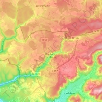
Name: Topografische Karte Plombières-les-Bains, Höhe, Relief.
Durchschnittliche Höhe: 516 m
Minimale Höhe: 314 m
Maximale Höhe: 680 m
Andere topografische Karten
Klicken Sie auf eine Karte, um ihre Topografie, ihre Höhe und ihr Relief anzuzeigen.
Saint-Remy
Saint-Remy, Saint-Dié-des-Vosges, Vosges, Grand Est, Metropolitan France, 88480, France
Durchschnittliche Höhe: 363 m
Harchéchamp
Harchéchamp, Neufchâteau, Vosges, Grand Est, Metropolitan France, 88300, France
Durchschnittliche Höhe: 348 m
Blevaincourt
Blevaincourt, Neufchâteau, Vosges, Grand Est, Metropolitan France, 88320, France
Durchschnittliche Höhe: 361 m
Le Chêne
France > Grand Est > Vosges > Rupt-sur-Moselle
Le Chêne, Rupt-sur-Moselle, Épinal, Vosges, Grand Est, Metropolitan France, 88360, France
Durchschnittliche Höhe: 576 m
Mont-lès-Neufchâteau
Mont-lès-Neufchâteau, Neufchâteau, Vosges, Grand Est, Metropolitan France, 88300, France
Durchschnittliche Höhe: 341 m
La Mergerie
France > Grand Est > Vosges > Chef-Haut
La Mergerie, Chef-Haut, Épinal, Vosges, Grand Est, Metropolitan France, 88500, France
Durchschnittliche Höhe: 360 m
Le Thillot
Le Thillot, Épinal, Vosges, Grand Est, Metropolitan France, 88160, France
Durchschnittliche Höhe: 623 m
Neufchâteau
Neufchâteau, Vosges, Grand Est, Metropolitan France, 88300, France
Durchschnittliche Höhe: 334 m
Nayemont
France > Grand Est > Vosges > Ban-de-Sapt
Nayemont, Ban-de-Sapt, Saint-Dié-des-Vosges, Vosges, Grand Est, Metropolitan France, 88210, France
Durchschnittliche Höhe: 604 m
La Croix Ferry
France > Grand Est > Vosges > Le Tholy > Le Rain Brice
La Croix Ferry, Le Rain Brice, Le Tholy, Saint-Dié-des-Vosges, Vosges, Grand Est, Metropolitan France, 88530, France
Durchschnittliche Höhe: 659 m
Raon-l'Étape
Raon-l'Étape, Saint-Dié-des-Vosges, Vosges, Grand Est, Metropolitan France, 88110, France
Durchschnittliche Höhe: 362 m
Rupt-sur-Moselle
France > Grand Est > Vosges > Rupt-sur-Moselle
Rupt-sur-Moselle, Épinal, Vosges, Grand Est, Metropolitan France, 88360, France
Durchschnittliche Höhe: 637 m
Les Poulières
France > Grand Est > Vosges > Les Poulières
Les Poulières, Saint-Dié-des-Vosges, Vosges, Grand Est, Metropolitan France, 88600, France
Durchschnittliche Höhe: 510 m
Colroy-la-Grande
France > Grand Est > Vosges > Provenchères-et-Colroy
Colroy-la-Grande, Provenchères-et-Colroy, Saint-Dié-des-Vosges, Vosges, Grand Est, Metropolitan France, 88490, France
Durchschnittliche Höhe: 516 m
Bettegney-Saint-Brice
France > Grand Est > Vosges > Bettegney-Saint-Brice
Bettegney-Saint-Brice, Épinal, Vosges, Grand Est, Metropolitan France, 88450, France
Durchschnittliche Höhe: 349 m
Laveline-devant-Bruyères
France > Grand Est > Vosges > Laveline-devant-Bruyères
Laveline-devant-Bruyères, Épinal, Vosges, Grand Est, Metropolitan France, 88600, France
Durchschnittliche Höhe: 492 m
Saint-Maurice-sur-Moselle
France > Grand Est > Vosges > Saint-Maurice-sur-Moselle
Saint-Maurice-sur-Moselle, Épinal, Vosges, Grand Est, Metropolitan France, 88560, France
Durchschnittliche Höhe: 815 m
Plainfaing
Plainfaing, Saint-Dié-des-Vosges, Vosges, Grand Est, Metropolitan France, 88230, France
Durchschnittliche Höhe: 815 m
Basse-sur-le-Rupt
France > Grand Est > Vosges > Basse-sur-le-Rupt
Basse-sur-le-Rupt, Saint-Dié-des-Vosges, Vosges, Grand Est, Metropolitan France, 88120, France
Durchschnittliche Höhe: 677 m
Schlitte Mountain
France > Grand Est > Vosges > La Bresse
Schlitte Mountain, Route de Vologne, La Bresse, Saint-Dié-des-Vosges, Vosges, Grand Est, Metropolitan France, 88250, France
Durchschnittliche Höhe: 1.032 m
Ollainville
Ollainville, Neufchâteau, Vosges, Grand Est, Metropolitan France, 88170, France
Durchschnittliche Höhe: 354 m
Bellefontaine
Bellefontaine, Épinal, Vosges, Grand Est, Metropolitan France, 88370, France
Durchschnittliche Höhe: 544 m