
Spenden
Rüsten Sie sich für Ihr nächstes Abenteuer:
Als Amazon-Partner verdient diese Website an qualifizierten Käufen, ohne dass Ihnen zusätzliche Kosten entstehen.
Topografische Karte Wigtown
Klicken Sie auf die Karte, um die Höhe anzuzeigen.
Spenden
Rüsten Sie sich für Ihr nächstes Abenteuer:
Als Amazon-Partner verdient diese Website an qualifizierten Käufen, ohne dass Ihnen zusätzliche Kosten entstehen.
Wigtown
Wigtown Castle was in existence by 1291, on flat land down by the River Bladnoch, (outlines clearly seen on an aerial view), whilst the town and church were on a hill, "an inversion of the usual arrangements". Nothing remains of the castle, although a strong natural site and indication of a large enclosed and defended area seems to point to a castle of the Edwardian type (Edward I) dating from the end of the 13th century. The site of the castle was excavated after a fashion about 1830, by a Captain Robert M’Kerlie and a team of volunteers. The outlines of a building were clearly traced on that occasion and a ditch, which had been broad, was distinctly seen on the north where there was also a semi-circular ridge of considerable elevation said to be the remains of the castle's outer wall. A few years later, a reporter in the New Statistical Account wrote that a fosse was quite discernible, although "the foundations of the walls cannot now be traced". Mortar and "other remains indicative of an ancient building" were still to be observed.
Spenden
Rüsten Sie sich für Ihr nächstes Abenteuer:
Als Amazon-Partner verdient diese Website an qualifizierten Käufen, ohne dass Ihnen zusätzliche Kosten entstehen.
Über diese Karte
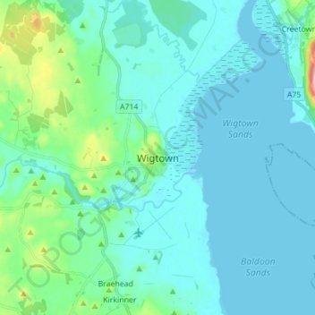
Name: Topografische Karte Wigtown, Höhe, Relief.
Durchschnittliche Höhe: 18 m
Minimale Höhe: -1 m
Maximale Höhe: 131 m
Spenden
Rüsten Sie sich für Ihr nächstes Abenteuer:
Als Amazon-Partner verdient diese Website an qualifizierten Käufen, ohne dass Ihnen zusätzliche Kosten entstehen.
Andere topografische Karten
Klicken Sie auf eine Karte, um ihre Topografie, ihre Höhe und ihr Relief anzuzeigen.
Spenden
Rüsten Sie sich für Ihr nächstes Abenteuer:
Als Amazon-Partner verdient diese Website an qualifizierten Käufen, ohne dass Ihnen zusätzliche Kosten entstehen.
Garden of Cosmic Speculation
United Kingdom > Scotland > Dumfries and Galloway
Durchschnittliche Höhe: 31 m
HIghtae Moss
United Kingdom > Scotland > Dumfries and Galloway > Lochmaben
Durchschnittliche Höhe: 63 m
Lochmaben Castle
United Kingdom > Scotland > Dumfries and Galloway > Lochmaben
Durchschnittliche Höhe: 48 m
Spenden
Rüsten Sie sich für Ihr nächstes Abenteuer:
Als Amazon-Partner verdient diese Website an qualifizierten Käufen, ohne dass Ihnen zusätzliche Kosten entstehen.
Lochrutton Loch
United Kingdom > Scotland > Dumfries and Galloway > Lochfoot
Durchschnittliche Höhe: 106 m
Spenden
Rüsten Sie sich für Ihr nächstes Abenteuer:
Als Amazon-Partner verdient diese Website an qualifizierten Käufen, ohne dass Ihnen zusätzliche Kosten entstehen.
Morton Castle
United Kingdom > Scotland > Dumfries and Galloway > Thornhill
Durchschnittliche Höhe: 190 m
Spenden
Rüsten Sie sich für Ihr nächstes Abenteuer:
Als Amazon-Partner verdient diese Website an qualifizierten Käufen, ohne dass Ihnen zusätzliche Kosten entstehen.
Spenden
Rüsten Sie sich für Ihr nächstes Abenteuer:
Als Amazon-Partner verdient diese Website an qualifizierten Käufen, ohne dass Ihnen zusätzliche Kosten entstehen.
Rhinns of Kellsc
United Kingdom > Scotland > Dumfries and Galloway
'Rhinns' derives from the Old Irish rind, later Ulster Irish and Scottish Gaelic rinn, meaning 'promontory' or 'point'. 'Kells' is a parish in the historic county of Stewartry of Kirkcudbright to the southeast of the range near New Galloway. Its name possibly derives from the Old Irish cell, later Irish and…
Durchschnittliche Höhe: 352 m
Spenden
Rüsten Sie sich für Ihr nächstes Abenteuer:
Als Amazon-Partner verdient diese Website an qualifizierten Käufen, ohne dass Ihnen zusätzliche Kosten entstehen.
River Dee
United Kingdom > Scotland > Dumfries and Galloway > Bridge of Dee
Durchschnittliche Höhe: 54 m
River Cree
United Kingdom > Scotland > Dumfries and Galloway > Newton Stewart
Durchschnittliche Höhe: 39 m
Spenden
Rüsten Sie sich für Ihr nächstes Abenteuer:
Als Amazon-Partner verdient diese Website an qualifizierten Käufen, ohne dass Ihnen zusätzliche Kosten entstehen.
Liddel Water
United Kingdom > Scotland > Dumfries and Galloway > Harelaw
Durchschnittliche Höhe: 177 m
Spenden
Rüsten Sie sich für Ihr nächstes Abenteuer:
Als Amazon-Partner verdient diese Website an qualifizierten Käufen, ohne dass Ihnen zusätzliche Kosten entstehen.