
Topografische Karte Mapusa
Klicken Sie auf die Karte, um die Höhe anzuzeigen.
Mapusa
Mapusa is located at 15°36′N 73°49′E / 15.60°N 73.82°E / 15.60; 73.82. It has an average elevation of 15 metres (49 feet).It lies on the banks of Mapusa River. Mapusa has a tropical climate with temperatures ranging from a high of 37 °C in summer with high levels of humidity to a low of 21 °C in winters.
Über diese Karte
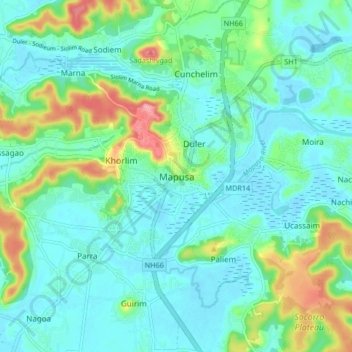
Name: Topografische Karte Mapusa, Höhe, Relief.
Ort: Mapusa, Bardez, North Goa, Goa, 403507, India (15.55085 73.77021 15.63085 73.85021)
Durchschnittliche Höhe: 26 m
Minimale Höhe: -3 m
Maximale Höhe: 110 m
Andere topografische Karten
Klicken Sie auf eine Karte, um ihre Topografie, ihre Höhe und ihr Relief anzuzeigen.