
Topografische Karte Don Carlos
Interaktive Karte
Klicken Sie auf die Karte, um die Höhe anzuzeigen.
Don Carlos
The terrain of the municipality of Don Carlos is generally flat except the mountain range on the eastern part of the municipality. The highest elevation is 700 metres (2,300 ft) above sea level and the lowest elevation is 300 metres (980 ft) below sea level.
Über diese Karte
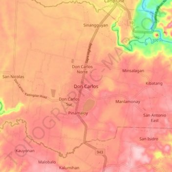
Name: Topografische Karte Don Carlos, Höhe, Relief.
Ort: Don Carlos, Bukidnon, Northern Mindanao, 088, Philippines (7.64036 124.95907 7.72036 125.03907)
Durchschnittliche Höhe: 299 m
Minimale Höhe: 161 m
Maximale Höhe: 355 m
Andere topografische Karten
Klicken Sie auf eine Karte, um ihre Topografie, ihre Höhe und ihr Relief anzuzeigen.