
Topografische Karte Cherthala
Interaktive Karte
Klicken Sie auf die Karte, um die Höhe anzuzeigen.
Über diese Karte
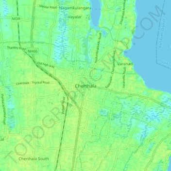
Name: Topografische Karte Cherthala, Höhe, Relief.
Ort: Cherthala, Alappuzha District, Kerala, 688524, India (9.64618 76.30261 9.72618 76.38261)
Durchschnittliche Höhe: 7 m
Minimale Höhe: -2 m
Maximale Höhe: 12 m
Andere topografische Karten
Klicken Sie auf eine Karte, um ihre Topografie, ihre Höhe und ihr Relief anzuzeigen.
Kakkanadu-Thenamara
Kakkanadu-Thenamara, Cherthala, Alappuzha District, Kerala, 688555, India
Durchschnittliche Höhe: 9 m
Pallippuram
Pallippuram, Cherthala, Alappuzha District, Kerala, 688547, India
Durchschnittliche Höhe: 5 m
Vembanad Lake
India > Kerala > Cherthala > Thaneermukkom
Vembanad Lake, Thaneermukkom, Cherthala, Alappuzha, Kerala, India
Durchschnittliche Höhe: 4 m
Kanjikkuzhi
Kanjikkuzhi, Cherthala, Alappuzha, Kerala, 688523, India
Durchschnittliche Höhe: 10 m