
Topografische Karte Zlatibor
Interaktive Karte
Klicken Sie auf die Karte, um die Höhe anzuzeigen.
Über diese Karte
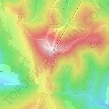
Name: Topografische Karte Zlatibor, Höhe, Relief.
Durchschnittliche Höhe: 1.218 m
Minimale Höhe: 956 m
Maximale Höhe: 1.487 m
Zlatibor itself is located in the northern part of the Stari Vlah region, a historical border region between Raška, Herzegovina and Bosnia. It spreads over an area of 300 square kilometres (120 square miles), 43 km (27 mi) in length, southeast to northwest, and up to 37 km (23 mi) in width. Its highest peak, Tornik, has an elevation of 1,496 m. Zlatibor is situated between 43° 31' N, and 43° 51' N, and between 19° 28' E and 19° 56' E.
Andere topografische Karten
Klicken Sie auf eine Karte, um ihre Topografie, ihre Höhe und ihr Relief anzuzeigen.
Dobroselica
Serbia > Central Serbia > Zlatibor Administrative District > Cajetina Municipality
Dobroselica, Cajetina Municipality, Zlatibor Administrative District, Central Serbia, Serbia
Durchschnittliche Höhe: 971 m
Sirogojno
Serbia > Central Serbia > Zlatibor Administrative District > Cajetina Municipality > Sirogojno
Sirogojno, Cajetina Municipality, Zlatibor Administrative District, Central Serbia, Serbia
Durchschnittliche Höhe: 867 m
Cajetina
Serbia > Central Serbia > Zlatibor Administrative District > Cajetina Municipality
Cajetina, Cajetina Municipality, Zlatibor Administrative District, Central Serbia, 31310, Serbia
Durchschnittliche Höhe: 888 m