
Topografische Karte Cantón Liberia
Interaktive Karte
Klicken Sie auf die Karte, um die Höhe anzuzeigen.
Cantón Liberia
Liberia has an area of 1,436.47 km2 and a mean elevation of 193 metres. Prominent geologic features of Liberia include Cerro Cacao (Cacao Mountain) and Rincón de la Vieja. The latter is the center of the Rincón de la Vieja Volcano National Park. The canton also includes the most visited portion of Santa Rosa National Park on its northwest border. The Río Salto delineates the southwestern border as far as the Tempisque River, and the Tempisque forms the border on the southeast as far as the Bahía Naranjo (Orange Bay).
Über diese Karte
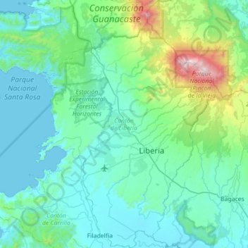
Name: Topografische Karte Cantón Liberia, Höhe, Relief.
Ort: Cantón Liberia, Provincia Guanacaste, Costa Rica (10.41830 -85.69929 10.96515 -85.29202)
Durchschnittliche Höhe: 237 m
Minimale Höhe: 0 m
Maximale Höhe: 1.878 m