
Topografische Karte Bowdoinham
Interaktive Karte
Klicken Sie auf die Karte, um die Höhe anzuzeigen.
Über diese Karte
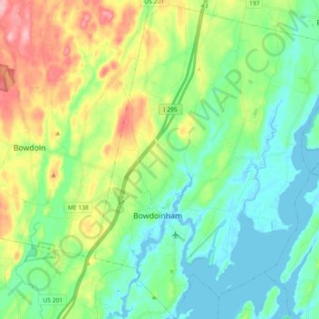
Name: Topografische Karte Bowdoinham, Höhe, Relief.
Ort: Bowdoinham, Sagadahoc County, Maine, 04008, United States (43.96660 -69.93530 44.09628 -69.79983)
Durchschnittliche Höhe: 44 m
Minimale Höhe: -5 m
Maximale Höhe: 142 m
Andere topografische Karten
Klicken Sie auf eine Karte, um ihre Topografie, ihre Höhe und ihr Relief anzuzeigen.
Georgetown Island
United States > Maine > Sagadahoc County > Georgetown
Georgetown Island, Georgetown, Sagadahoc County, Maine, 04548, United States
Durchschnittliche Höhe: 15 m
Woolwich
United States > Maine > Sagadahoc County
Woolwich, Sagadahoc County, Maine, 04579, United States
Durchschnittliche Höhe: 21 m
Arrowsic
United States > Maine > Sagadahoc County
Arrowsic, Sagadahoc County, Maine, United States
Durchschnittliche Höhe: 18 m
Richmond
United States > Maine > Sagadahoc County
Richmond, Sagadahoc County, Maine, 04357, United States
Durchschnittliche Höhe: 46 m
West Bath
United States > Maine > Sagadahoc County
West Bath, Sagadahoc County, Maine, United States
Durchschnittliche Höhe: 15 m
Drummore Bay
United States > Maine > Sagadahoc County > Phippsburg
Drummore Bay, Phippsburg, Sagadahoc County, Maine, 04562, United States
Durchschnittliche Höhe: 17 m
Topsham
United States > Maine > Sagadahoc County
Topsham, Sagadahoc County, Maine, 04086, United States
Durchschnittliche Höhe: 39 m
MacMahan Island
United States > Maine > Sagadahoc County > Georgetown
MacMahan Island, Georgetown, Sagadahoc County, Maine, United States
Durchschnittliche Höhe: 8 m
Phippsburg
United States > Maine > Sagadahoc County
Phippsburg, Sagadahoc County, Maine, United States
Durchschnittliche Höhe: 7 m
Georgetown
United States > Maine > Sagadahoc County
Georgetown, Sagadahoc County, Maine, 04548, United States
Durchschnittliche Höhe: 8 m
Bath
United States > Maine > Sagadahoc County
Bath, Sagadahoc County, Maine, 04530, United States
Durchschnittliche Höhe: 16 m