
Topografische Karte Emerson
Interaktive Karte
Klicken Sie auf die Karte, um die Höhe anzuzeigen.
Über diese Karte
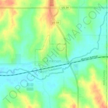
Name: Topografische Karte Emerson, Höhe, Relief.
Ort: Emerson, Mills County, Iowa, United States (41.01426 -95.40845 41.02371 -95.39650)
Durchschnittliche Höhe: 333 m
Minimale Höhe: 316 m
Maximale Höhe: 359 m
Andere topografische Karten
Klicken Sie auf eine Karte, um ihre Topografie, ihre Höhe und ihr Relief anzuzeigen.
Clark
United States > Iowa > Mills County
Clark, Mills County, Iowa, United States
Durchschnittliche Höhe: 314 m
Malvern
United States > Iowa > Mills County
Malvern, Mills County, Iowa, United States
Durchschnittliche Höhe: 317 m
Silver City
United States > Iowa > Mills County > Silver City > Silver City
Silver City, Mills County, Iowa, 51571, United States
Durchschnittliche Höhe: 340 m
Silver City
United States > Iowa > Mills County
Silver City, Mills County, Iowa, United States
Durchschnittliche Höhe: 333 m