
Spenden
Rüsten Sie sich für Ihr nächstes Abenteuer:
Als Amazon-Partner verdient diese Website an qualifizierten Käufen, ohne dass Ihnen zusätzliche Kosten entstehen.
Topografische Karte Chinauta
Klicken Sie auf die Karte, um die Höhe anzuzeigen.
Spenden
Rüsten Sie sich für Ihr nächstes Abenteuer:
Als Amazon-Partner verdient diese Website an qualifizierten Käufen, ohne dass Ihnen zusätzliche Kosten entstehen.
Über diese Karte
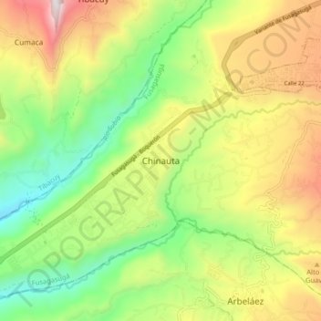
Name: Topografische Karte Chinauta, Höhe, Relief.
Durchschnittliche Höhe: 1.264 m
Minimale Höhe: 739 m
Maximale Höhe: 1.985 m
Spenden
Rüsten Sie sich für Ihr nächstes Abenteuer:
Als Amazon-Partner verdient diese Website an qualifizierten Käufen, ohne dass Ihnen zusätzliche Kosten entstehen.
Andere topografische Karten
Klicken Sie auf eine Karte, um ihre Topografie, ihre Höhe und ihr Relief anzuzeigen.
Cali
La ciudad es plana con una elevación promedia de 1000 msnm. Cali se sitúa además en un punto neurálgico y estratégico: hacia el occidente (aproximadamente 100 km) se conecta con el puerto de Buenaventura sobre el litoral pacífico, y al noreste el centro industrial de Yumbo con el que conforma el Área…
Durchschnittliche Höhe: 1.284 m
Valle del Cauca
Región plana o del Valle físico: Valle entre las cordilleras Central y Occidental de los Andes colombianos. Tiene aproximadamente 240 km de largo y su ancho varía entre 32 km (Yumbo y Palmira) y 12 km (Yotoco y Buga). El valle se encuentra a una altitud de 1000 m s. n. m. en promedio y abarca una superficie…
Durchschnittliche Höhe: 798 m
Tolima
Por estar el departamento del Tolima situado en la región del ecuador, no presenta ciclo estacional, pero disfruta de todos los niveles térmicos de montaña. Con cumbres nevadas a más de 5000 metros de altitud con las temperaturas bajo cero como el Nevado del Huila, el Nevado del Tolima, y le pertenecen…
Durchschnittliche Höhe: 1.687 m
Spenden
Rüsten Sie sich für Ihr nächstes Abenteuer:
Als Amazon-Partner verdient diese Website an qualifizierten Käufen, ohne dass Ihnen zusätzliche Kosten entstehen.
Antioquia
La localización de Antioquia en la zona ecuatorial de América influye en las temperaturas promedio de sus regiones, desde temperaturas muy altas en las tierras bajas de Urabá y del Nordeste, así como en las tierras bajas de los valles de los ríos Magdalena, Cauca, Porce y Nechí, hasta las muy frías de…
Durchschnittliche Höhe: 608 m
Spenden
Rüsten Sie sich für Ihr nächstes Abenteuer:
Als Amazon-Partner verdient diese Website an qualifizierten Käufen, ohne dass Ihnen zusätzliche Kosten entstehen.
Santander de Quilichao
Topográficamente hay dos zonas bien definidas: la zona plana, donde se inicia el valle geográfico del río Cauca y con explotaciones agropecuarias y tecnologías apropiadas. La zona de ladera: topografía ondulada suave, con diferencia de pisos térmicos que hacen que el establecimiento de actividades…
Durchschnittliche Höhe: 1.337 m
Spenden
Rüsten Sie sich für Ihr nächstes Abenteuer:
Als Amazon-Partner verdient diese Website an qualifizierten Käufen, ohne dass Ihnen zusätzliche Kosten entstehen.
Ibagué
Ibagué es un municipio colombiano ubicado en el centro-occidente de Colombia, sobre la Cordillera Central de los Andes entre el Cañón del Combeima y el Valle del Magdalena, en cercanías del Nevado del Tolima. Es la capital del departamento de Tolima. Se encuentra a una altitud promedio de 1285 m.s.n.m; su…
Durchschnittliche Höhe: 1.907 m
Spenden
Rüsten Sie sich für Ihr nächstes Abenteuer:
Als Amazon-Partner verdient diese Website an qualifizierten Käufen, ohne dass Ihnen zusätzliche Kosten entstehen.
Barranquilla
El sistema de alcantarillado de la ciudad es subterráneo y único. Las redes de drenaje conducen las aguas residuales en forma paralela a la red de agua potable hacia los cuerpos de agua sin recibir ningún tipo de tratamiento. De acuerdo con la topografía de Barranquilla, el alcantarillado se divide en tres…
Durchschnittliche Höhe: 22 m
Bogotá
Con la elevación de Bogotá a entidad de primer orden, se dio su separación política, fiscal y administrativa absoluta del departamento de Cundinamarca. Por ello desde la creación del Distrito Especial de Bogotá en 1954 (es decir, cuando se anexan los siete municipios vecinos), el ahora Distrito Capital…
Durchschnittliche Höhe: 2.711 m
Spenden
Rüsten Sie sich für Ihr nächstes Abenteuer:
Als Amazon-Partner verdient diese Website an qualifizierten Käufen, ohne dass Ihnen zusätzliche Kosten entstehen.
Suaza
El municipio de Suaza está situado sobre el costado occidental de la cordillera Oriental de los Andes colombianos y al suroriente del Departamento de Huila, en la región central del valle que forma el río Suaza y los Andes. Tiene una superficie total de 336 km². Al occidente el municipio colinda con la…
Durchschnittliche Höhe: 1.549 m
Spenden
Rüsten Sie sich für Ihr nächstes Abenteuer:
Als Amazon-Partner verdient diese Website an qualifizierten Käufen, ohne dass Ihnen zusätzliche Kosten entstehen.
Valledupar
Su territorio es llano y basculado hacia el suroriente mediante una leve pendiente. La ciudad se encuentra a una altitud que oscila entre los 246 m al norte (Planta de Tratamiento de Agua Potable) y 150 m al Sur (conjunto habitacional Casa de Campo), la altitud media es de 168 m (Plaza Alfonso López). Además…
Durchschnittliche Höhe: 1.087 m
Spenden
Rüsten Sie sich für Ihr nächstes Abenteuer:
Als Amazon-Partner verdient diese Website an qualifizierten Käufen, ohne dass Ihnen zusätzliche Kosten entstehen.
Montes de María
Montes de María (conocidos también como Serranía de San Jacinto) es una cadena montañosa de baja altitud localizada al norte de Colombia. La propia serranía y la zona circundante forma una subregión del Caribe colombiano de 6466 km², ubicada entre los departamentos de Sucre y Bolívar.
Durchschnittliche Höhe: 124 m
Spenden
Rüsten Sie sich für Ihr nächstes Abenteuer:
Als Amazon-Partner verdient diese Website an qualifizierten Käufen, ohne dass Ihnen zusätzliche Kosten entstehen.
Bogotá, Distrito Capital
Bogotá limita al sur con los departamentos del Meta (a través de Guamal, Cubarral y La Uribe) y del Huila (a través de Colombia), al norte con el municipio de Chía, al oeste con el río Bogotá y los municipios de Cota, Funza, Mosquera, Soacha (zona urbana), Pasca, San Bernardo, Arbeláez, Cabrera y…
Durchschnittliche Höhe: 2.183 m
Spenden
Rüsten Sie sich für Ihr nächstes Abenteuer:
Als Amazon-Partner verdient diese Website an qualifizierten Käufen, ohne dass Ihnen zusätzliche Kosten entstehen.
La Guajira
El departamento está conformado por el Macizo Guajiro al noreste, un macizo antiguo que abarca la península de La Guajira y comprende las serranías de Jarara Cocinas, Carpintero y La Makuira, esta última posee la máxima elevación que alcanza el cerro Palúa con 865 m; además el cerro LaTeta y Huitpana.
Durchschnittliche Höhe: 324 m
Meta
El territorio está dividido en tres regiones fisiográficas: la primera la constituye la parte montañosa oriental del departamento justo sobre el costado oriental de la cordillera Oriental, denominada piedemonte llanero, el cual es un sector montañoso y lluvioso con alturas que alcanzan los 4.306 m sobre el…
Durchschnittliche Höhe: 574 m
Spenden
Rüsten Sie sich für Ihr nächstes Abenteuer:
Als Amazon-Partner verdient diese Website an qualifizierten Käufen, ohne dass Ihnen zusätzliche Kosten entstehen.
Santander
Separadas del cuerpo de la cordillera, al centro del departamento, está un conjunto de montañas de mediana elevación, la Serranía de los Yariguíes. Comprende sectores de los municipios de Zapatoca, Betulia, Galán, El Hato, Palmar, Simacota, Palmas del Socorro, Chima, Contratación, El Guacamayo,…
Durchschnittliche Höhe: 1.362 m
Nariño
Nariño presenta una geografía diversa y clima variado según las altitudes: caluroso en la planicie del Pacífico y frío en la parte montañosa, donde vive la mayor parte de la población, situación que se repite en sentido norte-sur. Se caracteriza por su complicada topografía con respecto a otras zonas…
Durchschnittliche Höhe: 1.156 m
Montelíbano
El municipio de Montelíbano está localizado en el extremo suroriental del departamento de Córdoba, sobre la margen derecha del río San Jorge, con una superficie de 1.897 km la cabecera Municipal está a una altitud de 55 m s. n. m. y en todo el territorio varía entre 30 m s n. m. en las zonas aluviales y…
Durchschnittliche Höhe: 274 m
Spenden
Rüsten Sie sich für Ihr nächstes Abenteuer:
Als Amazon-Partner verdient diese Website an qualifizierten Käufen, ohne dass Ihnen zusätzliche Kosten entstehen.
Spenden
Rüsten Sie sich für Ihr nächstes Abenteuer:
Als Amazon-Partner verdient diese Website an qualifizierten Käufen, ohne dass Ihnen zusätzliche Kosten entstehen.
Villeta
El municipio de Villeta se encuentra ubicado sobre la zona noroccidental del Departamento de Cundinamarca. Pertenece a la Provincia del Gualivá. Situado al noroeste de Bogotá, en un valle pintoresco y fértil formado por las cuencas del Río Dulce y el Bituima, que unidos antes de llegar al casco urbano…
Durchschnittliche Höhe: 1.144 m
Spenden
Rüsten Sie sich für Ihr nächstes Abenteuer:
Als Amazon-Partner verdient diese Website an qualifizierten Käufen, ohne dass Ihnen zusätzliche Kosten entstehen.
Zipaquirá
La ciudad de Zipaquirá está situada en el Valle de El Abra, sobre la cordillera Oriental, en el altiplano cundiboyacense. El casco urbano se encuentra a una altitud de 2652 m s. n. m., lo que la convierte en la tercera ciudad con mayor altitud en Colombia con más de 100.000 habitantes de acuerdo a la lista…
Durchschnittliche Höhe: 2.893 m
Spenden
Rüsten Sie sich für Ihr nächstes Abenteuer:
Als Amazon-Partner verdient diese Website an qualifizierten Käufen, ohne dass Ihnen zusätzliche Kosten entstehen.
Neiva
Debido a su ubicación cerca de la línea del ecuador y su baja altitud, la ciudad tiene se encuentra en el piso térmico cálido con temperaturas anuales promedio durante el día que van desde 21 hasta 35 grado celsius. La variable temperatura siempre guarda cierta relación con la precipitación, de manera…
Durchschnittliche Höhe: 1.032 m
Spenden
Rüsten Sie sich für Ihr nächstes Abenteuer:
Als Amazon-Partner verdient diese Website an qualifizierten Käufen, ohne dass Ihnen zusätzliche Kosten entstehen.
Chinavita
Chinavita posee un clima variado gracias a los distintos pisos térmicos. Al oriente están las partes altas, y se destaca la Sabana de Mundo Nuevo, en donde se encuentra, entre otros atractivos, la Laguna de la Tarea. Posee además varios parajes naturales propicios para camping de montaña, con alturas de…
Durchschnittliche Höhe: 2.373 m
Montenegro
El municipio de Montenegro se localiza a 10 kilómetros al oeste de Armenia y a 300 kilómetros al suroeste de Bogotá a una altitud de 1.294 m s. n. m., con las coordenadas geográficas 4,34° Latitud Norte y 75,45° Longitud Oeste.
Durchschnittliche Höhe: 1.278 m
Valle de Aburrá
Forma parte de la cuenca natural del río Medellín. Este lo recorre de sur a norte, recibiendo una serie de afluentes a lo largo de su recorrido. El Valle tiene una longitud aproximada de 60 kilómetros y una amplitud variable. Está enmarcado por una topografía irregular y pendiente, con alturas que oscilan…
Durchschnittliche Höhe: 1.875 m
Spenden
Rüsten Sie sich für Ihr nächstes Abenteuer:
Als Amazon-Partner verdient diese Website an qualifizierten Käufen, ohne dass Ihnen zusätzliche Kosten entstehen.
Palmira
Los pisos térmicos que se presentan en la ciudad y zona rural de Palmira varían desde el clima frío en el Páramo de las Hermosas hasta la zona cálida del valle del río Cauca; su temperatura en el área urbana va desde los 18 °C a los 37 °C y su altitud es de 1001 metros. En Palmira hay dos zonas…
Durchschnittliche Höhe: 1.600 m
San Bernardo del Viento
El territorio corresponde a un bosque seco tropical, con predominio de relieve bajo, baja altitud y alta temperatura, con un promedio de 30 °C, una humedad relativa del 80%, dos épocas de lluvias durante el año, entre abril – mayo y octubre – noviembre, en donde se precipita el 76% de la lluvia anual…
Durchschnittliche Höhe: 11 m
Cúcuta
El territorio de Cúcuta es llano hacia el norte y montañoso en sus bordes y en su parte central, especialmente hacia el sur, en donde presenta por el oriente varias montañas, desprendidas de la cordillera Oriental de los Andes Colombianos. La ciudad está situada en el valle homónimo, al pie de la…
Durchschnittliche Höhe: 591 m
Túquerres
Entre 1935 y 1936, Túquerres fue desolada por una serie de movimientos telúricos que destruyeron además del centro urbano, el caserío de la chorrera dejando un saldo trágico de más de 1000 víctimas mortales, además de un notorio cambio en la topografía. Se reconstruye en el gobierno de López Pumarejo…
Durchschnittliche Höhe: 2.735 m
Spenden
Rüsten Sie sich für Ihr nächstes Abenteuer:
Als Amazon-Partner verdient diese Website an qualifizierten Käufen, ohne dass Ihnen zusätzliche Kosten entstehen.
Tabio
La actual iglesia fue terminada en 1904 por el Padre Andrés Avelino Pérez y se denominó Santa Bárbara, consagrada el 28 de diciembre de 1929. La capilla de la Virgen de Lourdes, ubicada al oriente de la serranía de Tiquiza, que separa a Tabio de Chía, en la vereda que lleva su nombre, fue terminada en…
Durchschnittliche Höhe: 2.772 m
Spenden
Rüsten Sie sich für Ihr nächstes Abenteuer:
Als Amazon-Partner verdient diese Website an qualifizierten Käufen, ohne dass Ihnen zusätzliche Kosten entstehen.
San Sebastián
La economía del Municipio se basa principalmente en prácticas agropecuarias, produciendo diversidad de alimentos debido al sistema montañoso y sus diferentes pisos altitudinales, con condiciones limitadas generalmente para el desarrollo de sus productos, de los cuales cabe destacar: La papa, y la…
Durchschnittliche Höhe: 2.632 m
Spenden
Rüsten Sie sich für Ihr nächstes Abenteuer:
Als Amazon-Partner verdient diese Website an qualifizierten Käufen, ohne dass Ihnen zusätzliche Kosten entstehen.
Risaralda
El departamento tiene una extensión de 4.140 km². El departamento está conformado por una zona central de topografía ligeramente ondulada a una elevación de 980m en el municipio de La Virginia . Esta zona está bordeada por las cordilleras Central y Occidental, la Central supera los 4.500m en los nevados…
Durchschnittliche Höhe: 1.355 m
Cesar
El departamento del Cesar posee un clima netamente tropical; sin embargo, dada la elevación de amplios sectores de terreno desde casi el nivel del mar hasta más de 5000 metros de altitud, presenta una gran variedad climática, con todos los pisos térmicos en sus versiones secas y húmedas.
Durchschnittliche Höhe: 413 m
Spenden
Rüsten Sie sich für Ihr nächstes Abenteuer:
Als Amazon-Partner verdient diese Website an qualifizierten Käufen, ohne dass Ihnen zusätzliche Kosten entstehen.
Une
El nombre "Une" proviene del muysc cubun, en el que significa "olla" o "cosa buena" también centro de reunión del cacicazgo de Ubaque. Según el diccionario de Acosta Ortegón, reflejando la influencia indígena en la zona. La topografía de Une, caracterizada por sus paisajes montañosos y ríos,…
Durchschnittliche Höhe: 3.019 m
Spenden
Rüsten Sie sich für Ihr nächstes Abenteuer:
Als Amazon-Partner verdient diese Website an qualifizierten Käufen, ohne dass Ihnen zusätzliche Kosten entstehen.
Casanare
El nombre del departamento proviene del vocablo sáliva Casanari, que significa Río de Aguas Negras. El territorio del departamento se extiende en el piedemonte oriental de la cordillera Oriental de los Andes colombianos. Pertenece a la región de los Llanos Orientales con todas las características que la…
Durchschnittliche Höhe: 557 m
Cartago
El municipio se encuentra en el norte del departamento del Valle del Cauca, siendo la puerta de entrada a este por esta zona, y además se encuentra ubicado en la Cordillera Central perteneciente a la Región Andina de Colombia, en una planicie a una altitud de unos 917 m s. n. m. Por el municipio pasan, por…
Durchschnittliche Höhe: 1.000 m
Putumayo
En la región del piedemonte, con el aumento de la altitud, las precipitaciones inicialmente aumentan hasta llegar a su óptimo pluviométrico entre los 2300 y 3500 mm, para luego descender rápidamente. La llanura se caracteriza por las altas temperaturas superiores a los 27 °C, con una precipitación…
Durchschnittliche Höhe: 677 m
Spenden
Rüsten Sie sich für Ihr nächstes Abenteuer:
Als Amazon-Partner verdient diese Website an qualifizierten Käufen, ohne dass Ihnen zusätzliche Kosten entstehen.
Caicedonia
Los primeros colonos llegados al territorio que hoy es Caicedonia provenían, en su mayoría, de los municipios de Guatapé, San Rafael, San Roque y Medellín. Inicialmente se establecieron en el llamado plan de Cuba, toda vez que su topografía les ofrecía ventajosas condiciones para levantar un caserío.
Durchschnittliche Höhe: 1.452 m
Spenden
Rüsten Sie sich für Ihr nächstes Abenteuer:
Als Amazon-Partner verdient diese Website an qualifizierten Käufen, ohne dass Ihnen zusätzliche Kosten entstehen.
Charalá
La cabecera municipal de Charalá dista 135 kilómetros de Bucaramanga, la capital del departamento. Territorio ondulado y fértil, situado a 1290 metros de altitud, es avenado por los ríos Táquiza, Pienta, Cañaverales, Riachuelito y Virolín. Registra una temperatura media anual de 21 grados Celsius. En…
Durchschnittliche Höhe: 2.091 m
Spenden
Rüsten Sie sich für Ihr nächstes Abenteuer:
Als Amazon-Partner verdient diese Website an qualifizierten Käufen, ohne dass Ihnen zusätzliche Kosten entstehen.
San Juan de Rioseco
San Juan de Rioseco es un municipio colombiano del departamento de Cundinamarca, ubicado en la Provincia de Magdalena Centro, de la cual es la capital. Se encuentra a 117 km de Bogotá, y a una altitud de 1303 m s. n. m.
Durchschnittliche Höhe: 1.109 m
Spenden
Rüsten Sie sich für Ihr nächstes Abenteuer:
Als Amazon-Partner verdient diese Website an qualifizierten Käufen, ohne dass Ihnen zusätzliche Kosten entstehen.