
Topografische Karte Ketildyngja
Interaktive Karte
Klicken Sie auf die Karte, um die Höhe anzuzeigen.
Über diese Karte
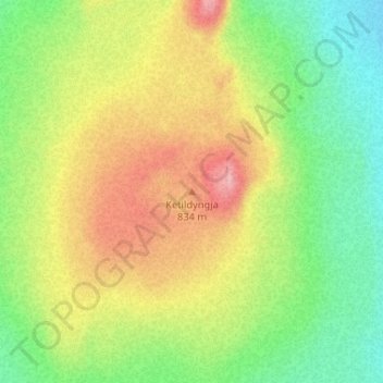
Name: Topografische Karte Ketildyngja, Höhe, Relief.
Ort: Ketildyngja, Skútustaðahreppur, Norðurland eystra, Island (65.43150 -16.64777 65.43160 -16.64767)
Durchschnittliche Höhe: 834 m
Minimale Höhe: 762 m
Maximale Höhe: 928 m
Andere topografische Karten
Klicken Sie auf eine Karte, um ihre Topografie, ihre Höhe und ihr Relief anzuzeigen.
Þingvellir
Þingvellir, Þingvallavegur, Bláskógabyggð, Suðurland, Island
Durchschnittliche Höhe: 316 m
Reykjahlíð
Reykjahlíð, Skútustaðahreppur, Norðurland eystra, Island
Durchschnittliche Höhe: 305 m
Snæfellsnes
Snæfellsnes, Vatnaleið, Helgafellssveit, Vesturland, Island
Durchschnittliche Höhe: 85 m
Þeistareykir
Þeistareykir, Þingeyjarsveit, Norðurland eystra, Island
Durchschnittliche Höhe: 395 m
Þrándarjökull
Þrándarjökull, Djúpavogshreppur, Austurland, Island
Durchschnittliche Höhe: 1.012 m
Sultartangalón
Sultartangalón, Búðarháls, Ásahreppur, Suðurland, Island
Durchschnittliche Höhe: 432 m
Þeistareykjabunga
Þeistareykjabunga, Þingeyjarsveit, Norðurland eystra, Island
Durchschnittliche Höhe: 506 m
Tindfjallajökull
Tindfjallajökull, Hungurfitaskáli, Rangárþing ytra, Suðurland, Island
Durchschnittliche Höhe: 1.059 m
Brennisteinsfjöll
Brennisteinsfjöll, Sveitarfélagið Ölfus, Suðurland, Island
Durchschnittliche Höhe: 370 m
Herðubreið
Herðubreið, Skútustaðahreppur, Norðurland eystra, Island
Durchschnittliche Höhe: 1.182 m
Skaftafellsjökull
Skaftafellsjökull, S4, Sveitarfélagið Hornafjörður, Austurland, Island
Durchschnittliche Höhe: 539 m