
Topografische Karte Uttar Pradesh
Interaktive Karte
Klicken Sie auf die Karte, um die Höhe anzuzeigen.
Über diese Karte
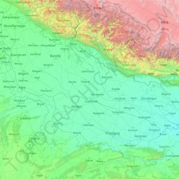
Name: Topografische Karte Uttar Pradesh, Höhe, Relief.
Ort: Uttar Pradesh, India (23.87063 77.08388 30.40638 84.63451)
Durchschnittliche Höhe: 954 m
Minimale Höhe: 47 m
Maximale Höhe: 7.878 m
Uttar Pradesh, with a total area of 243,290 square kilometres (93,935 sq mi), is India's fourth-largest state in terms of land area and is roughly of same size as United Kingdom. It is situated on the northern spout of India and shares an international boundary with Nepal. The Himalayas border the state on the north, but the plains that cover most of the state are distinctly different from those high mountains. The larger Gangetic Plain region is in the north; it includes the Ganges-Yamuna Doab, the Ghaghra plains, the Ganges plains and the Terai. The smaller Vindhya Range and plateau region are in the south. It is characterised by hard rock strata and a varied topography of hills, plains, valleys and plateaus. The Bhabhar tract gives place to the terai area which is covered with tall elephant grass and thick forests interspersed with marshes and swamps. The sluggish rivers of the bhabhar deepen in this area, their course running through a tangled mass of thick undergrowth. The terai runs parallel to the bhabhar in a thin strip. The entire alluvial plain is divided into three sub-regions. The first in the eastern tract consisting of 14 districts which are subject to periodical floods and droughts and have been classified as scarcity areas. These districts have the highest density of population which gives the lowest per capita land. The other two regions, the central and the western, are comparatively better with a well-developed irrigation system. They suffer from waterlogging and large-scale user tracts. In addition, the area is fairly arid. The state has more than 32 large and small rivers; of them, the Ganga, Yamuna, Saraswati, Sarayu, Betwa, and Ghaghara are larger and of religious importance in Hinduism.
Andere topografische Karten
Klicken Sie auf eine Karte, um ihre Topografie, ihre Höhe und ihr Relief anzuzeigen.
Hyderabad
India > Telangana > Bahadurpura mandal
Hyderabad, Bahadurpura mandal, Hyderabad District, Telangana, India
Durchschnittliche Höhe: 549 m
Navi Mumbai
India > Maharashtra > Thane > Navi Mumbai
Navi Mumbai, Mumbai Metropolitan Region, Thane, Maharashtra, 400706, India
Durchschnittliche Höhe: 30 m
Bengaluru
India > Karnataka > Bangalore North
Bengaluru, Bangalore North, Bengaluru Urban District, Karnataka, India
Durchschnittliche Höhe: 881 m
Anaikatti
India > Tamil Nadu > Coimbatore North
Anaikatti, Mannarkad, Palakkad District, Kerala, 678741, India
Durchschnittliche Höhe: 623 m
Jhimar
India > Uttarakhand > Molekhal
Jhimar, Molekhal, Almora District, Uttarakhand, India
Durchschnittliche Höhe: 1.663 m
Lingoda
India > Madhya Pradesh > Agar Tahsil
Lingoda, Agar Tahsil, Agar Malwa District, Madhya Pradesh, India
Durchschnittliche Höhe: 478 m
Thalai Nagar
India > Tamil Nadu > Veppanthattai > Thaluthalai
Thalai Nagar, Thaluthalai, Veppanthattai, Perambalur District, Tamil Nadu, 621103, India
Durchschnittliche Höhe: 146 m
Barkuru
India > Karnataka > Brahmavara taluku
Barkuru, Brahmavara taluku, Udupi District, Karnataka, 576210, India
Durchschnittliche Höhe: 13 m
Chennai
India > Tamil Nadu > Chennai
Chennai, Chennai District, Tamil Nadu, India
Durchschnittliche Höhe: 8 m
Vadodara
India > Gujarat > Vadodara Taluka
Vadodara, Vadodara Taluka, Vadodara District, Gujarat, 390001, India
Durchschnittliche Höhe: 36 m
Surat
India > Gujarat > Katargam Taluka > Surat
Surat, Katargam Taluka, Surat, Gujarat, 395001, India
Durchschnittliche Höhe: 11 m
Pune
India > Maharashtra > Pune City > Pune
Pune, Pune City, Pune District, Maharashtra, 411001, India
Durchschnittliche Höhe: 641 m
Musi River
Musi River, Hyderabad, Uppal mandal, Medchal–Malkajgiri, Telangana, 5000036, India
Durchschnittliche Höhe: 490 m
Dharamshala
India > Himachal Pradesh > Dharamshala
Dharamshala, Kangra District, Himachal Pradesh, 176200, India
Durchschnittliche Höhe: 1.781 m
Thiruvananthapuram
India > Kerala > Thiruvananthapuram
Thiruvananthapuram, Thiruvananthapuram District, Kerala, 695001, India
Durchschnittliche Höhe: 33 m
Dehradun
India > Uttarakhand > Dehradun
Dehradun, Dehradun District, Uttarakhand, 248001, India
Durchschnittliche Höhe: 904 m
Devanahalli
India > Karnataka > Devanahalli taluk
Devanahalli, Devanahalli taluk, Bengaluru Rural District, Karnataka, 562110, India
Durchschnittliche Höhe: 900 m
Dahej
India > Gujarat > Vagra Taluka
Dahej, Vagra Taluka, Bharuch District, Gujarat, 393125, India
Durchschnittliche Höhe: 6 m
Delhi
India > Delhi > Kotwali Tehsil
Delhi, Kotwali Tehsil, Central Delhi, Delhi, 110006, India
Durchschnittliche Höhe: 216 m
Bhopal
India > Madhya Pradesh > Huzur Tahsil
Bhopal, Huzur Tahsil, Bhopal District, Madhya Pradesh, 462001, India
Durchschnittliche Höhe: 498 m
Salem
Salem, Salem District, Tamil Nadu, 636001, India
Durchschnittliche Höhe: 418 m
Hatan
India > Rajasthan > Asind Tehsil
Hatan, Asind Tehsil, Bhilwara District, Rajasthan, 311204, India
Durchschnittliche Höhe: 462 m
Chennimalai
India > Tamil Nadu > Perundurai
Chennimalai, Perundurai, Erode District, Tamil Nadu, 638051, India
Durchschnittliche Höhe: 267 m
Koloriang
India > Arunachal Pradesh > Koloriang HQ
Koloriang, Koloriang HQ, Kurung Kumey District, Arunachal Pradesh, India
Durchschnittliche Höhe: 1.791 m
Sion Fort
India > Maharashtra > Mumbai
Sion Fort, Road No 1, Sion Koliwada, F/N Ward, Zone 2, Mumbai, Maharashtra, 400022, India
Durchschnittliche Höhe: 6 m
Kanyakumari district
Kanyakumari district, Tamil Nadu, India
Durchschnittliche Höhe: 226 m
Coimbatore district
Coimbatore district, Tamil Nadu, India
Durchschnittliche Höhe: 552 m
Barkur
India > Madhya Pradesh > Kundam Tahsil
Barkur, Kundam Tahsil, Jabalpur District, Madhya Pradesh, India
Durchschnittliche Höhe: 478 m
Krishnagiri District
Krishnagiri District, Tamil Nadu, India
Durchschnittliche Höhe: 653 m
Madurai
India > Tamil Nadu > Madurai
Madurai, Madurai South, Madurai district, Tamil Nadu, India
Durchschnittliche Höhe: 138 m
Kishangarh
India > Rajasthan > Kishangarh Tehsil
Kishangarh, Kishangarh Tehsil, Ajmer District, Rajasthan, 305802, India
Durchschnittliche Höhe: 448 m
Kharki
India > Madhya Pradesh > Pandhana Tahsil
Kharki, Pandhana Tahsil, Khandwa District, Madhya Pradesh, India
Durchschnittliche Höhe: 317 m