
Topografische Karte Faye
Interaktive Karte
Klicken Sie auf die Karte, um die Höhe anzuzeigen.
Über diese Karte
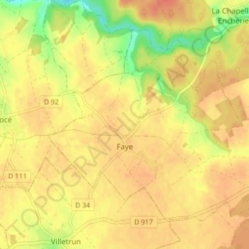
Name: Topografische Karte Faye, Höhe, Relief.
Durchschnittliche Höhe: 125 m
Minimale Höhe: 96 m
Maximale Höhe: 138 m
Andere topografische Karten
Klicken Sie auf eine Karte, um ihre Topografie, ihre Höhe und ihr Relief anzuzeigen.
Savigny-sur-Braye
France > Centre-Val de Loire > Loir-et-Cher
Savigny-sur-Braye, Vendôme, Loir-et-Cher, Centre-Val de Loire, Metropolitan France, 41360, France
Durchschnittliche Höhe: 129 m
Pray
France > Centre-Val de Loire > Loir-et-Cher
Pray, Vendôme, Loir-et-Cher, Centre-Val de Loire, Metropolitan France, 41190, France
Durchschnittliche Höhe: 127 m
Couëtron-au-Perche
France > Centre-Val de Loire > Loir-et-Cher
Couëtron-au-Perche, Vendôme, Loir-et-Cher, Centre-Val de Loire, Metropolitan France, 41170, France
Durchschnittliche Höhe: 176 m
Blois
France > Centre-Val de Loire > Loir-et-Cher
Blois, Loir-et-Cher, Centre-Val de Loire, Metropolitan France, 41000, France
Durchschnittliche Höhe: 95 m