
Topografische Karte Saint John
Interaktive Karte
Klicken Sie auf die Karte, um die Höhe anzuzeigen.
Über diese Karte
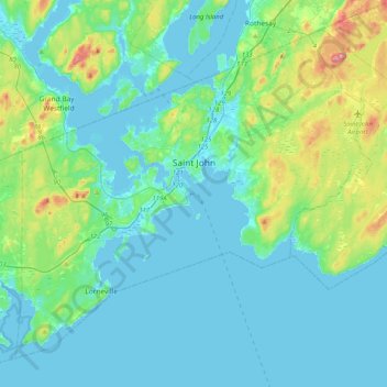
Name: Topografische Karte Saint John, Höhe, Relief.
Ort: Saint John, Saint John County, New Brunswick, Canada (45.13325 -66.24562 45.37693 -65.83886)
Durchschnittliche Höhe: 38 m
Minimale Höhe: -7 m
Maximale Höhe: 226 m
The topography surrounding Saint John is hilly; a result of the influence of two coastal mountain ranges which run along the Bay of Fundy – the St. Croix Highlands and the Caledonia Highlands. The soil throughout the region is extremely rocky with frequent granite outcrops. The coastal plain hosts numerous freshwater lakes in the eastern, western and northern parts of the city.
Andere topografische Karten
Klicken Sie auf eine Karte, um ihre Topografie, ihre Höhe und ihr Relief anzuzeigen.
Drury Cove
Canada > New Brunswick > Saint John County > Saint John
Drury Cove, Saint John, Saint John County, New Brunswick, E2K 5K7, Canada
Durchschnittliche Höhe: 24 m
Tynemouth Creek
Canada > New Brunswick > Saint John County
Tynemouth Creek, Saint Martins Parish, Saint John County, New Brunswick, Canada
Durchschnittliche Höhe: 32 m
Little River
Canada > New Brunswick > Saint John County > Saint John
Little River, Saint John, Saint John County, New Brunswick, E2J 1N8, Canada
Durchschnittliche Höhe: 9 m
Lorneville
Canada > New Brunswick > Saint John County > Saint John > Lorneville
Lorneville, Saint John, Saint John County, New Brunswick, E2M 7G6, Canada
Durchschnittliche Höhe: 18 m