
Topografische Karte Distrikt Mokhotlong
Interaktive Karte
Klicken Sie auf die Karte, um die Höhe anzuzeigen.
Über diese Karte
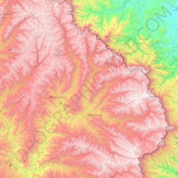
Name: Topografische Karte Distrikt Mokhotlong, Höhe, Relief.
Ort: Distrikt Mokhotlong, Lesotho (-29.58166 28.55597 -28.75596 29.45571)
Durchschnittliche Höhe: 2.435 m
Minimale Höhe: 1.029 m
Maximale Höhe: 3.463 m
Andere topografische Karten
Klicken Sie auf eine Karte, um ihre Topografie, ihre Höhe und ihr Relief anzuzeigen.
Thaba-Bosiu
Lesotho > Distrikt Thaba-Tseka
Thaba-Bosiu, Distrikt Thaba-Tseka, Lesotho
Durchschnittliche Höhe: 2.547 m
Mohobollo
Lesotho > Distrikt Leribe > Litlhoatšaneng Ha-Lelahla
Mohobollo, Litlhoatšaneng Ha-Lelahla, Distrikt Leribe, Lesotho
Durchschnittliche Höhe: 1.652 m
Masitise
Masitise, Distrikt Quthing, Lesotho
Durchschnittliche Höhe: 1.605 m
Sebapala
Lesotho > Distrikt Quthing > Ha Robi
Sebapala, Ha Robi, Distrikt Quthing, Lesotho
Durchschnittliche Höhe: 1.515 m
Matlakeng
Lesotho > Distrikt Butha-Buthe
Matlakeng, Distrikt Butha-Buthe, Lesotho
Durchschnittliche Höhe: 2.532 m
Mahobong Moreneng
Mahobong Moreneng, Distrikt Leribe, Lesotho
Durchschnittliche Höhe: 1.688 m
Likhetlane
Likhetlane, Distrikt Leribe, Lesotho
Durchschnittliche Höhe: 1.639 m
Ho Keonane
Ho Keonane, Distrikt Mokhotlong, Lesotho
Durchschnittliche Höhe: 2.547 m
Sehlabathebe National Park
Lesotho > Qacha's Nek District
Sehlabathebe National Park, Qacha's Nek District, Lesotho
Durchschnittliche Höhe: 2.331 m
Mafadi
Mafadi, Mokhotlong District, Lesotho
Durchschnittliche Höhe: 3.285 m
Thabana Ntlenyana
Thabana Ntlenyana, Mokhotlong District, Lesotho
Durchschnittliche Höhe: 3.313 m