
Topografische Karte Oceanside
Interaktive Karte
Klicken Sie auf die Karte, um die Höhe anzuzeigen.
Über diese Karte
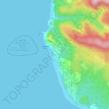
Name: Topografische Karte Oceanside, Höhe, Relief.
Ort: Oceanside, Tillamook County, Oregon, 97134, United States (45.43945 -123.98856 45.47945 -123.94856)
Durchschnittliche Höhe: 62 m
Minimale Höhe: -5 m
Maximale Höhe: 308 m
Andere topografische Karten
Klicken Sie auf eine Karte, um ihre Topografie, ihre Höhe und ihr Relief anzuzeigen.
Siskeyville
United States > Oregon > Tillamook County
Siskeyville, Tillamook County, Oregon, United States
Durchschnittliche Höhe: 263 m
Pacific City
United States > Oregon > Tillamook County
Pacific City, Tillamook County, Oregon, 97135, United States
Durchschnittliche Höhe: 25 m
Manzanita
United States > Oregon > Tillamook County
Manzanita, Tillamook County, Oregon, 97130, United States
Durchschnittliche Höhe: 15 m
Nehalem
United States > Oregon > Tillamook County
Nehalem, Tillamook County, Oregon, United States
Durchschnittliche Höhe: 16 m
Landslide
United States > Oregon > Tillamook County
Landslide, Tillamook County, Oregon, United States
Durchschnittliche Höhe: 574 m
Woods
United States > Oregon > Tillamook County > Woods
Woods, Tillamook County, Oregon, 97315, United States
Durchschnittliche Höhe: 47 m
Netarts
United States > Oregon > Tillamook County > Netarts
Netarts, Tillamook County, Oregon, United States
Durchschnittliche Höhe: 35 m
Oceanside
United States > Oregon > Tillamook County > Oceanside
Oceanside, Tillamook County, Oregon, 97134, United States
Durchschnittliche Höhe: 61 m