
Topografische Karte Farris
Interaktive Karte
Klicken Sie auf die Karte, um die Höhe anzuzeigen.
Über diese Karte
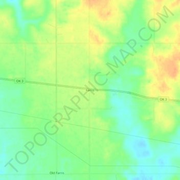
Name: Topografische Karte Farris, Höhe, Relief.
Ort: Farris, Atoka County, Oklahoma, United States (34.24238 -95.88636 34.28238 -95.84636)
Durchschnittliche Höhe: 163 m
Minimale Höhe: 146 m
Maximale Höhe: 181 m
Andere topografische Karten
Klicken Sie auf eine Karte, um ihre Topografie, ihre Höhe und ihr Relief anzuzeigen.
Daisy
United States > Oklahoma > Atoka County
Daisy, Atoka County, Oklahoma, United States
Durchschnittliche Höhe: 251 m
Caney
United States > Oklahoma > Atoka County
Caney, Atoka County, Oklahoma, 74533, United States
Durchschnittliche Höhe: 169 m
Chockie
United States > Oklahoma > Atoka County
Chockie, Atoka County, Oklahoma, United States
Durchschnittliche Höhe: 221 m
Atoka
United States > Oklahoma > Atoka County
Atoka, Atoka County, Oklahoma, United States
Durchschnittliche Höhe: 184 m
Limestone Gap
United States > Oklahoma > Atoka County
Limestone Gap, Atoka County, Oklahoma, United States
Durchschnittliche Höhe: 232 m
Wesley
United States > Oklahoma > Atoka County
Wesley, Atoka County, Oklahoma, United States
Durchschnittliche Höhe: 250 m
Tushka
United States > Oklahoma > Atoka County
Tushka, Atoka County, Oklahoma, United States
Durchschnittliche Höhe: 188 m
Bentley
United States > Oklahoma > Atoka County
Bentley, Atoka County, Oklahoma, United States
Durchschnittliche Höhe: 165 m
Wardville
United States > Oklahoma > Atoka County
Wardville, Atoka County, Oklahoma, 74576, United States
Durchschnittliche Höhe: 210 m
Boggy Depot State Park
United States > Oklahoma > Atoka County
Boggy Depot State Park, Atoka County, Oklahoma, United States
Durchschnittliche Höhe: 177 m
Hopewell
United States > Oklahoma > Atoka County
Hopewell, Atoka County, Oklahoma, United States
Durchschnittliche Höhe: 219 m
Redden
United States > Oklahoma > Atoka County
Redden, Atoka County, Oklahoma, United States
Durchschnittliche Höhe: 220 m
Stringtown
United States > Oklahoma > Atoka County
Stringtown, Atoka County, Oklahoma, United States
Durchschnittliche Höhe: 197 m
Lane
United States > Oklahoma > Atoka County
Lane, Atoka County, Oklahoma, 74555, United States
Durchschnittliche Höhe: 178 m