
Topografische Karte Saint Joseph
Interaktive Karte
Klicken Sie auf die Karte, um die Höhe anzuzeigen.
Über diese Karte
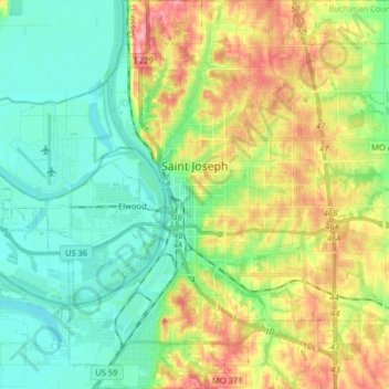
Name: Topografische Karte Saint Joseph, Höhe, Relief.
Ort: Saint Joseph, Buchanan County, Missouri, United States (39.69722 -94.89903 39.82126 -94.74334)
Durchschnittliche Höhe: 277 m
Minimale Höhe: 241 m
Maximale Höhe: 343 m
Under the Köppen climate classification, St. Joseph has a humid subtropical climate (Cfa) bordering on a humid continental climate (Dfa), although under United States isotherms of 32 °F (0 °C) the station is firmly continental. The monthly weather averages listed below are taken from National Weather Service 1981-2010 Normals recorded at Rosecrans Airport. Because of the Airport's location near the Missouri River and at a low elevation, official overnight lows during wintertime especially are often several degrees colder than at other places within the city. Snowfall is not recorded at the St Joseph weather station although surrounding reporting stations typically receive 12-20 inches of snowfall annually.
Andere topografische Karten
Klicken Sie auf eine Karte, um ihre Topografie, ihre Höhe und ihr Relief anzuzeigen.
Lewis and Clark Village
United States > Missouri > Buchanan County
Lewis and Clark Village, Buchanan County, Missouri, United States
Durchschnittliche Höhe: 247 m
Easton
United States > Missouri > Buchanan County
Easton, Buchanan County, Missouri, United States
Durchschnittliche Höhe: 288 m
Rushville
United States > Missouri > Buchanan County
Rushville, Buchanan County, Missouri, United States
Durchschnittliche Höhe: 271 m
De Kalb
United States > Missouri > Buchanan County
De Kalb, Buchanan County, Missouri, United States
Durchschnittliche Höhe: 337 m
Dearborn Reservoir Dam
United States > Missouri > Buchanan County > Dearborn
Dearborn Reservoir Dam, Dearborn, Buchanan County, Missouri, 64439, United States
Durchschnittliche Höhe: 289 m
Agency
United States > Missouri > Buchanan County
Agency, Buchanan County, Missouri, United States
Durchschnittliche Höhe: 270 m
Faucett
United States > Missouri > Buchanan County
Faucett, Buchanan County, Missouri, 64448, United States
Durchschnittliche Höhe: 305 m