Topografische Karte Lapela
Interaktive Karte
Klicken Sie auf die Karte, um die Höhe anzuzeigen.
Über diese Karte
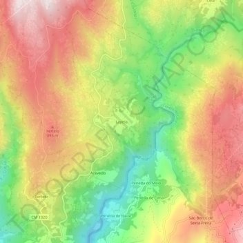
Name: Topografische Karte Lapela, Höhe, Relief.
Ort: Lapela, Cabril, Montalegre, Vila Real, Portugal (41.72815 -8.01407 41.76815 -7.97407)
Durchschnittliche Höhe: 714 m
Minimale Höhe: 384 m
Maximale Höhe: 1.027 m
Andere topografische Karten
Klicken Sie auf eine Karte, um ihre Topografie, ihre Höhe und ihr Relief anzuzeigen.
Miradouro de Fafião
Portugal > Vila Real > Montalegre > Cabril > Fafião
Miradouro de Fafião, Rua da Portela do Monte, Fafião, Cabril, Montalegre, Vila Real, 4850-336, Portugal
Durchschnittliche Höhe: 487 m
Sete Lagoas
Portugal > Vila Real > Montalegre > Cabril
Sete Lagoas, Cabril, Montalegre, Vila Real, Portugal
Durchschnittliche Höhe: 934 m
Poço da Corga de Pena Calva
Portugal > Vila Real > Montalegre > Cabril
Poço da Corga de Pena Calva, Cabril, Montalegre, Vila Real, Portugal
Durchschnittliche Höhe: 1.090 m
Barragem do Ribeiro do Penedo
Portugal > Vila Real > Montalegre > Cabril
Barragem do Ribeiro do Penedo, Cabril, Montalegre, Vila Real, Portugal
Durchschnittliche Höhe: 900 m
Minas dos Carris
Portugal > Vila Real > Montalegre > Cabril
Minas dos Carris, Cabril, Montalegre, Vila Real, Portugal
Durchschnittliche Höhe: 1.349 m
Fafião
Portugal > Vila Real > Montalegre > Cabril
Fafião, Cabril, Montalegre, Vila Real, 4850-336, Portugal
Durchschnittliche Höhe: 488 m