
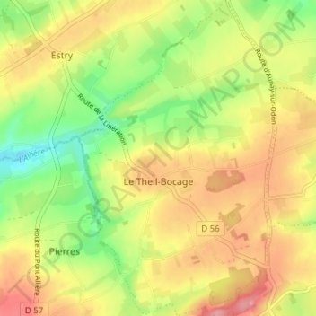
Topografische Karte Le Theil-Bocage
Interaktive Karte
Klicken Sie auf die Karte, um die Höhe anzuzeigen.
Über diese Karte
Name: Topografische Karte Le Theil-Bocage, Höhe, Relief.
Durchschnittliche Höhe: 201 m
Minimale Höhe: 148 m
Maximale Höhe: 250 m
Andere topografische Karten
Klicken Sie auf eine Karte, um ihre Topografie, ihre Höhe und ihr Relief anzuzeigen.
Vassy
France > Normandie > Calvados > Valdallière
Vassy, Valdallière, Vire, Calvados, Normandie, France métropolitaine, 14410, France
Durchschnittliche Höhe: 178 m
Le Douit
France > Normandie > Calvados > Valdallière
Le Douit, Burcy, Valdallière, Vire, Calvados, Normandie, France métropolitaine, 14410, France
Durchschnittliche Höhe: 183 m
Estry
France > Normandie > Calvados > Valdallière
Estry, Valdallière, Vire, Calvados, Normandie, France métropolitaine, 14410, France
Durchschnittliche Höhe: 194 m
Burcy
France > Normandie > Calvados > Valdallière
Burcy, Valdallière, Vire, Calvados, Normandie, France métropolitaine, 14410, France
Durchschnittliche Höhe: 178 m
Pierres
France > Normandie > Calvados > Valdallière
Pierres, Valdallière, Vire, Calvados, Normandie, France métropolitaine, 14410, France
Durchschnittliche Höhe: 204 m
Montchamp
France > Normandie > Calvados > Valdallière
Montchamp, Valdallière, Vire, Calvados, Normandie, France métropolitaine, 14350, France
Durchschnittliche Höhe: 196 m
Noron
France > Normandie > Calvados > Valdallière
Noron, Bernières-le-Patry, Valdallière, Vire, Calvados, Normandie, France métropolitaine, 14410, France
Durchschnittliche Höhe: 216 m
Bernières-le-Patry
France > Normandie > Calvados > Valdallière
Bernières-le-Patry, Valdallière, Vire, Calvados, Normandie, France métropolitaine, 14410, France
Durchschnittliche Höhe: 202 m
Le Désert
France > Normandie > Calvados > Valdallière
Le Désert, Valdallière, Vire, Calvados, Normandie, France métropolitaine, 14350, France
Durchschnittliche Höhe: 156 m
Presles
France > Normandie > Calvados > Valdallière
Presles, Valdallière, Vire, Calvados, Normandie, France métropolitaine, 14410, France
Durchschnittliche Höhe: 183 m