
Topografische Karte Brech
Klicken Sie auf die Karte, um die Höhe anzuzeigen.
Brech
Le relief de la commune forme un plan incliné vers le sud-est, les altitudes variant entre 66 mètres (au nord-ouest du finage communal, près de Mané er Groëz, et le niveau de la mer atteint dans l'angle sud-est du territoire communal, là où le Loc'h quitte le territoire communal au niveau du pont ferroviaire de Toul er Goug. Le bourg est vers 50 mètres d'altitude, excentré dans la partie est de la commune.
Über diese Karte
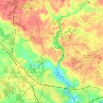
Name: Topografische Karte Brech, Höhe, Relief.
Durchschnittliche Höhe: 39 m
Minimale Höhe: -8 m
Maximale Höhe: 67 m
Andere topografische Karten
Klicken Sie auf eine Karte, um ihre Topografie, ihre Höhe und ihr Relief anzuzeigen.
Berric
France > Bretagne > Morbihan > Berric > Berric
Berric est située dans le Morbihan en Bretagne, à la frontière du pays gallo et du pays breton, à mi-chemin de Vannes et de Questembert. La commune est vallonnée au nord et encaissée par de profondes vallées. Les ruisseaux de la partie ouest de la commune sont tributaires du golfe du Morbihan tandis que…
Durchschnittliche Höhe: 69 m
Quily
France > Bretagne > Morbihan > Val d'Oust
Le finage de l'ancienne commune de Quily est constitué pour l'essentiel d'un plateau bosselé qui culmine à l'extrême ouest de son territoire à 135 mètres d'altitude et dont la pente décroit en direction de l'est jusque vers 70 mètres d'altitude. Ce plateau est limité par un escarpement d'une…
Durchschnittliche Höhe: 71 m
Plage de Kerpape
France > Bretagne > Morbihan > Plœmeur > Pen Palud
La partie intérieure de la commune est constituée pour l'essentiel d'un plateau qui ne dépasse qu'à peine 50 mètres d'altitude, le terril de la carrière de kaolin de Kergantic étant le sommet le plus visible de loin.
Durchschnittliche Höhe: 5 m