
Topografische Karte Roaring Spring
Interaktive Karte
Klicken Sie auf die Karte, um die Höhe anzuzeigen.
Über diese Karte
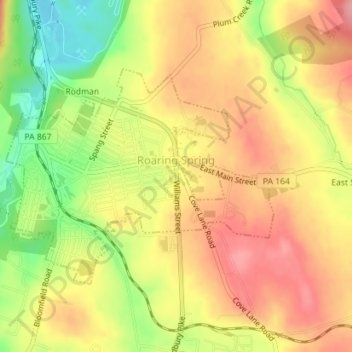
Name: Topografische Karte Roaring Spring, Höhe, Relief.
Ort: Roaring Spring, Blair County, Pennsylvania, United States (40.32637 -78.40802 40.34291 -78.38101)
Durchschnittliche Höhe: 396 m
Minimale Höhe: 332 m
Maximale Höhe: 442 m
Roaring Spring was established around the Big Spring in Morrison's Cove, a clean and dependable water source vital to the operation of a paper mill. Prior to 1866, when the first paper mill was built, Roaring Spring had been a grist mill hamlet with a country store at the intersection of two rural roads that lead to the mill near the spring. A grist mill, powered by the spring water, had operated at that location since at least the 1760s. After 1867, as the paper mill expanded, surrounding tracts of land were acquired to accommodate housing development for new workers. The formalization of a town plan, however, never occurred. As a result, the seemingly random street pattern of the historic district is the product of hilly topography, a small network of pre-existing country roads that converged near the Big Spring, and the property lines of adjacent tracts that were acquired through the years for community expansion. The arterial streets of the district are now East Main, West Main, Spang and Bloomfield, each of which leads out of the borough to surrounding townships. Two of these streets — Spang and East Main — meet with Church Street at the district's main intersection called "Five Points." The boundaries of the district essentially include those portions of Roaring Spring Borough which had been laid out for development by the early 1920s. This area encompasses 233 acres (0.94 km2) or 55 percent of the borough's area of 421 acres (1.70 km2). Since the district's period of significance extends to 1944, most of those buildings erected after the 1920s were built as infill within the areas already subdivided by the 1920s. In the early 1960s, the Borough began to annex sections of adjacent Taylor Township, especially to the east around the then new Rt. 36 Bypass.
Andere topografische Karten
Klicken Sie auf eine Karte, um ihre Topografie, ihre Höhe und ihr Relief anzuzeigen.
Mill Run
United States > Pennsylvania > Blair County > Altoona > Allegheny Furnace
Mill Run, Allegheny Furnace, Altoona, Blair County, Pennsylvania, 16603, United States
Durchschnittliche Höhe: 349 m
Pinecroft
United States > Pennsylvania > Blair County > Antis Township
Pinecroft, Antis Township, Blair County, Pennsylvania, 16617, United States
Durchschnittliche Höhe: 354 m
Calvert Hills
United States > Pennsylvania > Blair County > Altoona
Calvert Hills, Altoona, Blair County, Pennsylvania, 16601, United States
Durchschnittliche Höhe: 412 m
Tyrone
United States > Pennsylvania > Blair County > Tyrone
Tyrone, Blair County, Pennsylvania, United States
Durchschnittliche Höhe: 341 m
Mill Run
United States > Pennsylvania > Blair County > Altoona > Llyswen
Mill Run, Llyswen, Altoona, Blair County, Pennsylvania, United States
Durchschnittliche Höhe: 340 m
Greenwood
United States > Pennsylvania > Blair County > Logan Township > Greenwood
Greenwood, Logan Township, Blair County, Pennsylvania, 166602, United States
Durchschnittliche Höhe: 426 m
Altoona
United States > Pennsylvania > Blair County
Altoona, Blair County, Pennsylvania, United States
Durchschnittliche Höhe: 443 m
Mill Run
United States > Pennsylvania > Blair County > Logan Township
Mill Run, Logan Township, Blair County, Pennsylvania, 16603, United States
Durchschnittliche Höhe: 443 m
Hollidaysburg
United States > Pennsylvania > Blair County
Hollidaysburg, Blair County, Pennsylvania, United States
Durchschnittliche Höhe: 311 m