
Topografische Karte Pounding Mill
Interaktive Karte
Klicken Sie auf die Karte, um die Höhe anzuzeigen.
Über diese Karte
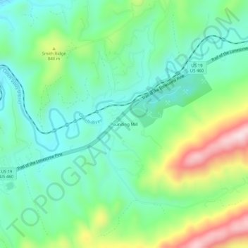
Name: Topografische Karte Pounding Mill, Höhe, Relief.
Durchschnittliche Höhe: 745 m
Minimale Höhe: 612 m
Maximale Höhe: 1.050 m
Andere topografische Karten
Klicken Sie auf eine Karte, um ihre Topografie, ihre Höhe und ihr Relief anzuzeigen.
Tazewell
United States > Virginia > Tazewell County
Tazewell, Tazewell County, Virginia, United States
Durchschnittliche Höhe: 805 m
Tiptop
United States > Virginia > Tazewell County
Tiptop, Tazewell County, Virginia, United States
Durchschnittliche Höhe: 864 m
Bandy
United States > Virginia > Tazewell County
Bandy, Tazewell County, Virginia, United States
Durchschnittliche Höhe: 734 m
Glen Burke
United States > Virginia > Tazewell County
Glen Burke, Tazewell County, Virginia, United States
Durchschnittliche Höhe: 804 m
Raven
United States > Virginia > Tazewell County
Raven, Tazewell County, Virginia, United States
Durchschnittliche Höhe: 715 m
North Tazewell
United States > Virginia > Tazewell County > Tazewell
North Tazewell, Tazewell, Tazewell County, Virginia, 24651, United States
Durchschnittliche Höhe: 774 m
Abbs Valley
United States > Virginia > Tazewell County
Abbs Valley, Tazewell County, Virginia, United States
Durchschnittliche Höhe: 844 m
Mud Fork
United States > Virginia > Tazewell County > Mud Fork
Mud Fork, Tazewell County, Virginia, United States
Durchschnittliche Höhe: 878 m
Bluefield
United States > Virginia > Tazewell County
Bluefield, Tazewell County, Virginia, 24605, United States
Durchschnittliche Höhe: 849 m
Lake Witten
United States > Virginia > Tazewell County
Lake Witten, Tazewell County, Virginia, United States
Durchschnittliche Höhe: 821 m
Lamberts Store
United States > Virginia > Tazewell County > Lamberts Store
Lamberts Store, Tazewell County, Virginia, 24601, United States
Durchschnittliche Höhe: 718 m
Indian
United States > Virginia > Tazewell County > Cedar Bluff
Indian, Cedar Bluff, Tazewell County, Virginia, 24609, United States
Durchschnittliche Höhe: 681 m
Burkes Garden
United States > Virginia > Tazewell County
Burkes Garden, Tazewell County, Virginia, 24608, United States
Durchschnittliche Höhe: 947 m
Clinch Mountain
United States > Virginia > Tazewell County
Clinch Mountain, Tazewell County, Virginia, 24377, United States
Durchschnittliche Höhe: 981 m
Richlands
United States > Virginia > Tazewell County
Richlands, Tazewell County, Virginia, United States
Durchschnittliche Höhe: 671 m
Rich Mountain
United States > Virginia > Tazewell County
Rich Mountain, Tazewell County, Virginia, 24655, United States
Durchschnittliche Höhe: 952 m