
Topografische Karte Carvers Gap
Interaktive Karte
Klicken Sie auf die Karte, um die Höhe anzuzeigen.
Über diese Karte
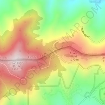
Name: Topografische Karte Carvers Gap, Höhe, Relief.
Ort: Carvers Gap, Mitchell County, North Carolina, United States (36.10641 -82.11092 36.10651 -82.11082)
Durchschnittliche Höhe: 1.586 m
Minimale Höhe: 1.261 m
Maximale Höhe: 1.904 m
Andere topografische Karten
Klicken Sie auf eine Karte, um ihre Topografie, ihre Höhe und ihr Relief anzuzeigen.
Bailey
United States > North Carolina > Mitchell County
Bailey, Mitchell County, North Carolina, 28740, United States
Durchschnittliche Höhe: 760 m
Grassy Creek
United States > North Carolina > Mitchell County
Grassy Creek, Mitchell County, North Carolina, 28777, United States
Durchschnittliche Höhe: 840 m
Spruce Pine
United States > North Carolina > Mitchell County
Spruce Pine, Mitchell County, North Carolina, 28777, United States
Durchschnittliche Höhe: 877 m
Bakersville
United States > North Carolina > Mitchell County
Bakersville, Mitchell County, North Carolina, 28705, United States
Durchschnittliche Höhe: 793 m