
Topografische Karte Saint-Claud
Interaktive Karte
Klicken Sie auf die Karte, um die Höhe anzuzeigen.
Über diese Karte
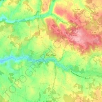
Name: Topografische Karte Saint-Claud, Höhe, Relief.
Durchschnittliche Höhe: 160 m
Minimale Höhe: 101 m
Maximale Höhe: 224 m
Andere topografische Karten
Klicken Sie auf eine Karte, um ihre Topografie, ihre Höhe und ihr Relief anzuzeigen.
Chasseneuil-sur-Bonnieure
France > Nouvelle-Aquitaine > Charente
Chasseneuil-sur-Bonnieure, Confolens, Charente, Nouvelle-Aquitaine, Metropolitan France, 16260, France
Durchschnittliche Höhe: 139 m
La Broue
France > Nouvelle-Aquitaine > Charente > Saint-Gourson
La Broue, Saint-Gourson, Confolens, Charente, Nouvelle-Aquitaine, Metropolitan France, 16700, France
Durchschnittliche Höhe: 124 m
Soyaux
France > Nouvelle-Aquitaine > Charente
Soyaux, Angoulême, Charente, Nouvelle-Aquitaine, Metropolitan France, 16800, France
Durchschnittliche Höhe: 104 m
Grassac
France > Nouvelle-Aquitaine > Charente
Grassac, Angoulême, Charente, Nouvelle-Aquitaine, Metropolitan France, 16380, France
Durchschnittliche Höhe: 151 m
Bouteville
France > Nouvelle-Aquitaine > Charente
Bouteville, Cognac, Charente, Nouvelle-Aquitaine, Metropolitan France, 16120, France
Durchschnittliche Höhe: 79 m
Champagne-Mouton
France > Nouvelle-Aquitaine > Charente
Champagne-Mouton, Confolens, Charente, Nouvelle-Aquitaine, Metropolitan France, 16350, France
Durchschnittliche Höhe: 167 m
Oriolles
France > Nouvelle-Aquitaine > Charente
Oriolles, Cognac, Charente, Nouvelle-Aquitaine, Metropolitan France, 16480, France
Durchschnittliche Höhe: 127 m
Angeduc
France > Nouvelle-Aquitaine > Charente
Angeduc, Cognac, Charente, Nouvelle-Aquitaine, Metropolitan France, 16300, France
Durchschnittliche Höhe: 86 m
Châteauneuf-sur-Charente
France > Nouvelle-Aquitaine > Charente
Châteauneuf-sur-Charente, Cognac, Charente, Nouvelle-Aquitaine, Metropolitan France, 16120, France
Durchschnittliche Höhe: 57 m
Bonnes
France > Nouvelle-Aquitaine > Charente
Bonnes, Angoulême, Charente, Nouvelle-Aquitaine, Metropolitan France, 16390, France
Durchschnittliche Höhe: 65 m
Condéon
France > Nouvelle-Aquitaine > Charente
Condéon, Cognac, Charente, Nouvelle-Aquitaine, Metropolitan France, 16360, France
Durchschnittliche Höhe: 108 m
Les Cossardières
France > Nouvelle-Aquitaine > Charente
Les Cossardières, Yvrac-et-Malleyrand, Angoulême, Charente, Nouvelle-Aquitaine, Metropolitan France, 16110, France
Durchschnittliche Höhe: 245 m
Lessac
France > Nouvelle-Aquitaine > Charente
Lessac, Confolens, Charente, Nouvelle-Aquitaine, Metropolitan France, 16500, France
Durchschnittliche Höhe: 187 m
Oradour-Fanais
France > Nouvelle-Aquitaine > Charente
Oradour-Fanais, Confolens, Charente, Nouvelle-Aquitaine, Metropolitan France, 16500, France
Durchschnittliche Höhe: 213 m
Saint-Maurice-des-Lions
France > Nouvelle-Aquitaine > Charente
Saint-Maurice-des-Lions, Confolens, Charente, Nouvelle-Aquitaine, Metropolitan France, 16500, France
Durchschnittliche Höhe: 196 m
Pairs
France > Nouvelle-Aquitaine > Charente > Saint-Christophe
Pairs, Saint-Christophe, Confolens, Charente, Nouvelle-Aquitaine, Metropolitan France, 16420, France
Durchschnittliche Höhe: 264 m
Saulgond
France > Nouvelle-Aquitaine > Charente
Saulgond, Confolens, Charente, Nouvelle-Aquitaine, Metropolitan France, 16420, France
Durchschnittliche Höhe: 223 m
Salles-de-Barbezieux
France > Nouvelle-Aquitaine > Charente
Salles-de-Barbezieux, Cognac, Charente, Nouvelle-Aquitaine, Metropolitan France, 16300, France
Durchschnittliche Höhe: 81 m
Brigueuil
France > Nouvelle-Aquitaine > Charente
Brigueuil, Confolens, Charente, Nouvelle-Aquitaine, Metropolitan France, 16420, France
Durchschnittliche Höhe: 267 m
Saint-Séverin
France > Nouvelle-Aquitaine > Charente > Saint-Séverin
Saint-Séverin, Angoulême, Charente, Nouvelle-Aquitaine, Metropolitan France, 16390, France
Durchschnittliche Höhe: 78 m
Pillac
France > Nouvelle-Aquitaine > Charente > Pillac
Pillac, Angoulême, Charente, Nouvelle-Aquitaine, Metropolitan France, 16390, France
Durchschnittliche Höhe: 104 m
Marthon
France > Nouvelle-Aquitaine > Charente
Marthon, Angoulême, Charente, Nouvelle-Aquitaine, Metropolitan France, 16380, France
Durchschnittliche Höhe: 135 m
Angoulême
France > Nouvelle-Aquitaine > Charente
Angoulême, Charente, Nouvelle-Aquitaine, Metropolitan France, 16000, France
Durchschnittliche Höhe: 73 m
Ruffec
France > Nouvelle-Aquitaine > Charente
Ruffec, Confolens, Charente, Nouvelle-Aquitaine, Metropolitan France, 16700, France
Durchschnittliche Höhe: 117 m
Confolens
France > Nouvelle-Aquitaine > Charente
Confolens, Charente, Nouvelle-Aquitaine, Metropolitan France, 16500, France
Durchschnittliche Höhe: 183 m
Jarnac
France > Nouvelle-Aquitaine > Charente
Jarnac, Cognac, Charente, Nouvelle-Aquitaine, Metropolitan France, 16200, France
Durchschnittliche Höhe: 24 m
Marcillac-Lanville
France > Nouvelle-Aquitaine > Charente
Marcillac-Lanville, Cognac, Charente, Nouvelle-Aquitaine, Metropolitan France, 16140, France
Durchschnittliche Höhe: 76 m
Nanteuil-en-Vallée
France > Nouvelle-Aquitaine > Charente
Nanteuil-en-Vallée, Confolens, Charente, Nouvelle-Aquitaine, Metropolitan France, 16700, France
Durchschnittliche Höhe: 147 m