
Topografische Karte Aringay
Interaktive Karte
Klicken Sie auf die Karte, um die Höhe anzuzeigen.
Über diese Karte
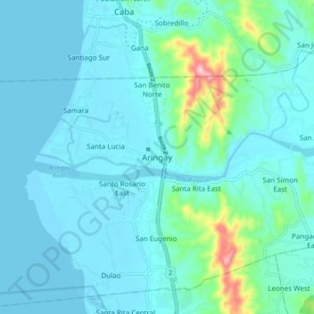
Name: Topografische Karte Aringay, Höhe, Relief.
Ort: Aringay, La Union, Ilocos Region, 2502, Philippines (16.35467 120.31435 16.43467 120.39435)
Durchschnittliche Höhe: 37 m
Minimale Höhe: -1 m
Maximale Höhe: 286 m
Andere topografische Karten
Klicken Sie auf eine Karte, um ihre Topografie, ihre Höhe und ihr Relief anzuzeigen.
Macabato
Philippines > La Union > Aringay
Macabato, Aringay, La Union, Ilocos Region, Philippines
Durchschnittliche Höhe: 100 m
San Eugenio
Philippines > La Union > Aringay > San Eugenio
San Eugenio, Aringay, La Union, Ilocos Region, 2503, Philippines
Durchschnittliche Höhe: 40 m
Dulao
Philippines > La Union > Aringay
Dulao, Aringay, La Union, Ilocos Region, 2503, Philippines
Durchschnittliche Höhe: 11 m