
Topografische Karte Aztec
Interaktive Karte
Klicken Sie auf die Karte, um die Höhe anzuzeigen.
Über diese Karte
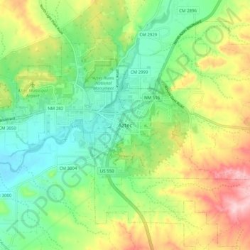
Name: Topografische Karte Aztec, Höhe, Relief.
Ort: Aztec, San Juan County, New Mexico, 87410, United States (36.78206 -108.03290 36.86206 -107.95290)
Durchschnittliche Höhe: 1.767 m
Minimale Höhe: 1.688 m
Maximale Höhe: 1.899 m
Yet another area managed by the BLM, this area was formed about the same time as the Bisti and Ah-Shi-Sle-Pah. This region offers a uniquely different scale of landscape. Hoodoo in this region are massive and the terrain much greater in elevation differences, thereby exposing a greater geological time frame than the Bisti or Ah-Shi-Sle-Pah. This region is a bit more accessible due to oil field roads traversing the region. However, extreme caution is required when driving on as these roads as they are impassible when wet.