
Topografische Karte Columbus
Interaktive Karte
Klicken Sie auf die Karte, um die Höhe anzuzeigen.
Über diese Karte
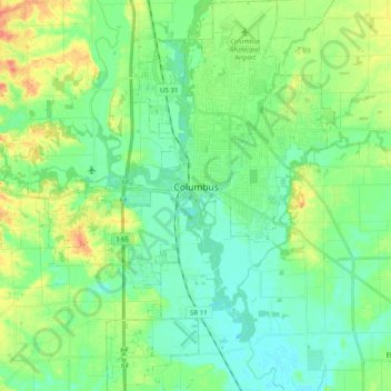
Name: Topografische Karte Columbus, Höhe, Relief.
Ort: Columbus, Bartholomew County, Indiana, United States (39.12060 -86.00298 39.27485 -85.85090)
Durchschnittliche Höhe: 197 m
Minimale Höhe: 181 m
Maximale Höhe: 231 m
Andere topografische Karten
Klicken Sie auf eine Karte, um ihre Topografie, ihre Höhe und ihr Relief anzuzeigen.
North Gate
United States > Indiana > Bartholomew County
North Gate, Bartholomew County, Indiana, 47280, United States
Durchschnittliche Höhe: 197 m
Haw Creek
United States > Indiana > Bartholomew County > Hope
Haw Creek, Hope, Bartholomew County, Indiana, United States
Durchschnittliche Höhe: 209 m
Hartsville
United States > Indiana > Bartholomew County
Hartsville, Bartholomew County, Indiana, United States
Durchschnittliche Höhe: 230 m
Hope
United States > Indiana > Bartholomew County > Hope
Hope, Bartholomew County, Indiana, United States
Durchschnittliche Höhe: 221 m
Corn Brook
United States > Indiana > Bartholomew County > Columbus > Corn Brook
Corn Brook, Columbus, Bartholomew County, Indiana, United States
Durchschnittliche Höhe: 196 m