
Topografische Karte Baie Saguenay
Interaktive Karte
Klicken Sie auf die Karte, um die Höhe anzuzeigen.
Über diese Karte
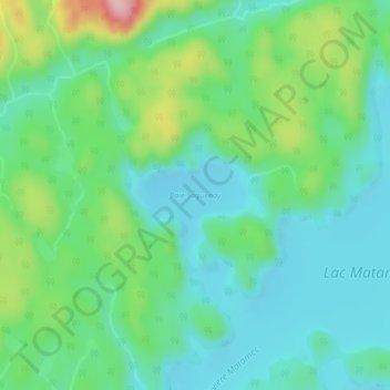
Name: Topografische Karte Baie Saguenay, Höhe, Relief.
Durchschnittliche Höhe: 163 m
Minimale Höhe: 115 m
Maximale Höhe: 291 m
Andere topografische Karten
Klicken Sie auf eine Karte, um ihre Topografie, ihre Höhe und ihr Relief anzuzeigen.
Rivière Moisie
Rivière Moisie, Sept-Îles, Sept-Rivières, Côte-Nord, Québec, Canada
Durchschnittliche Höhe: 182 m
Lac Gamache
Lac Gamache, Route 138, Sept-Îles, Sept-Rivières, Côte-Nord, Québec, Canada
Durchschnittliche Höhe: 116 m
Lac Labrie
Lac Labrie, Sentier motoneige Station Gallix, Sept-Îles, Sept-Rivières, Côte-Nord, Québec, Canada
Durchschnittliche Höhe: 105 m